WHAT'S ON


Language:


Sites
You haven’t got any favourites yet
This is where you can collect inspiration, articles, events and places that interest you.
Click the icon on pages and they’ll appear here.
Your favourites
Inspiration & Articles
Events & Tours
Places
Hiking
Search
Search results
INSPIRATION & ARTICLES
Read More
EVENTS & HIKES
Read More
Places
Read More
Gøtueiði - Støðlafjall - Gøtueiði


Link Copied!

-

-
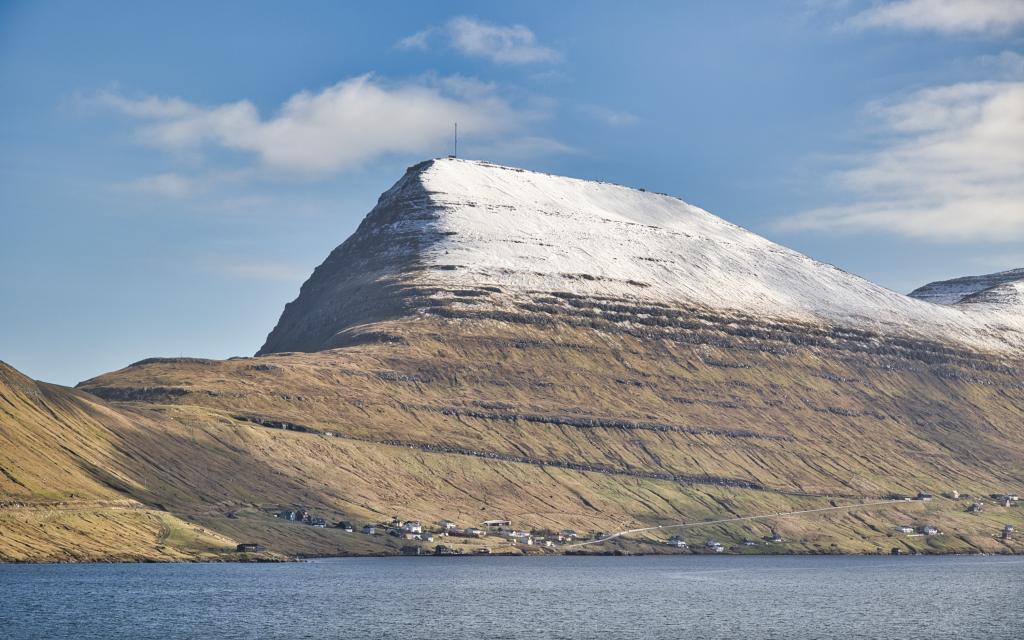 Støðlafjall, 517m
 -
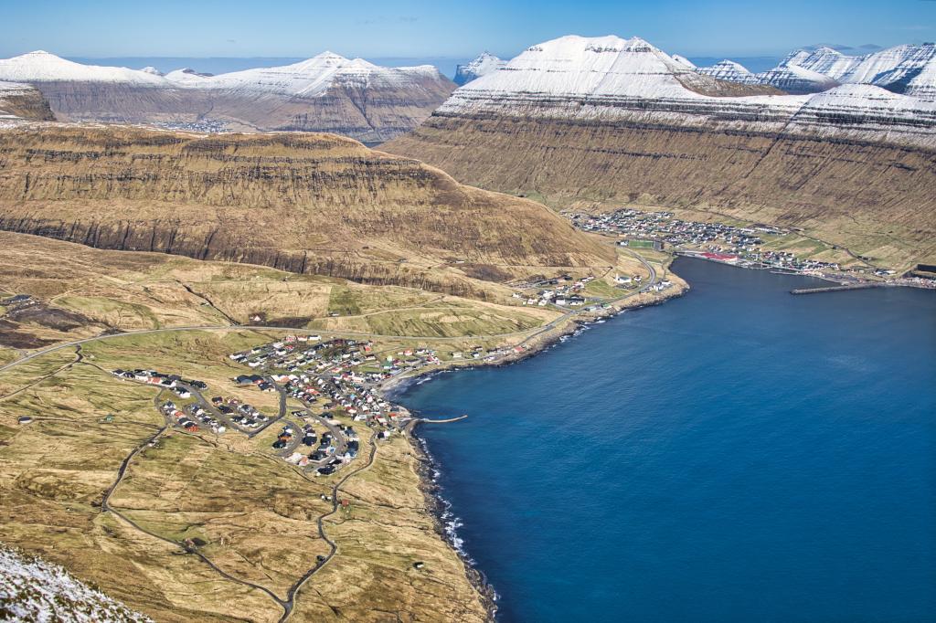 Veiw of Gøta
 -
-
-
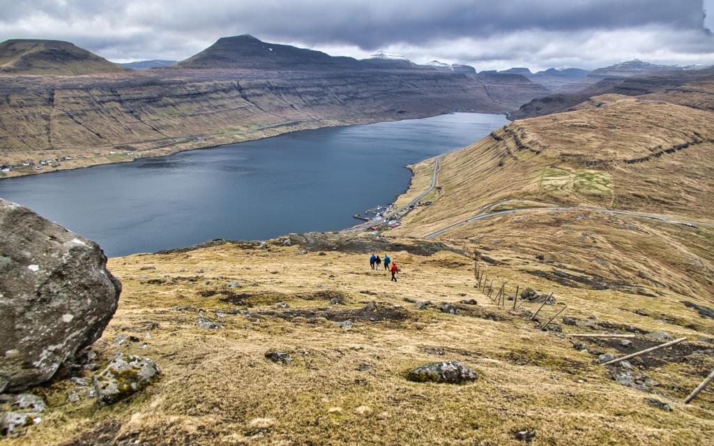
 Veiw of Skálafjørðurin
 -
 Veiw of Skálafjørðurin
-
-
Støðlafjall, 517m
-
Veiw of Gøta
-
-
-
Veiw of Skálafjørðurin
-
Veiw of Skálafjørðurin
Experience the Gøtueiði - Støðlafjall - Gøtueiði hike with stunning panoramic views, rich history, and vibrant Faroese nature.
Start at the parking lot at Gøtueiði, walk through the gate, and follow the trail upwards. The route across Gøtueiði has always been important, historically used for gatherings and military movements.From Gøtueiði to Støðlafjall
Follow the path southward and up towards the fence. Walk first on the eastern side of the fence and later on the western side as you ascend Støðlafjall. Upon reaching Hálsin, the surroundings become peaceful, with abundant birdlife. Cross over the fence using the stile and continue upwards.
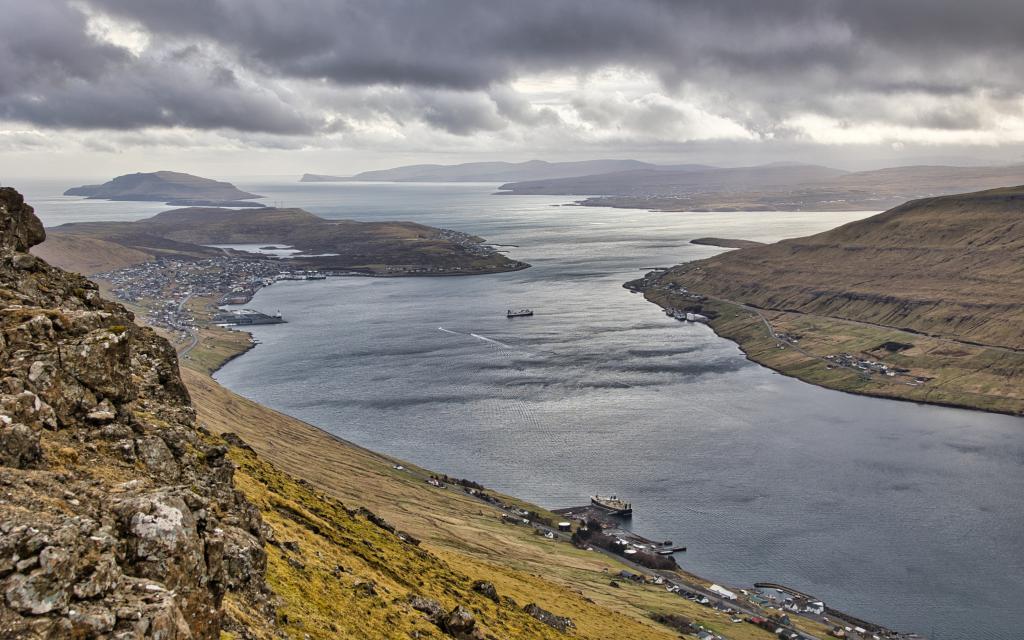
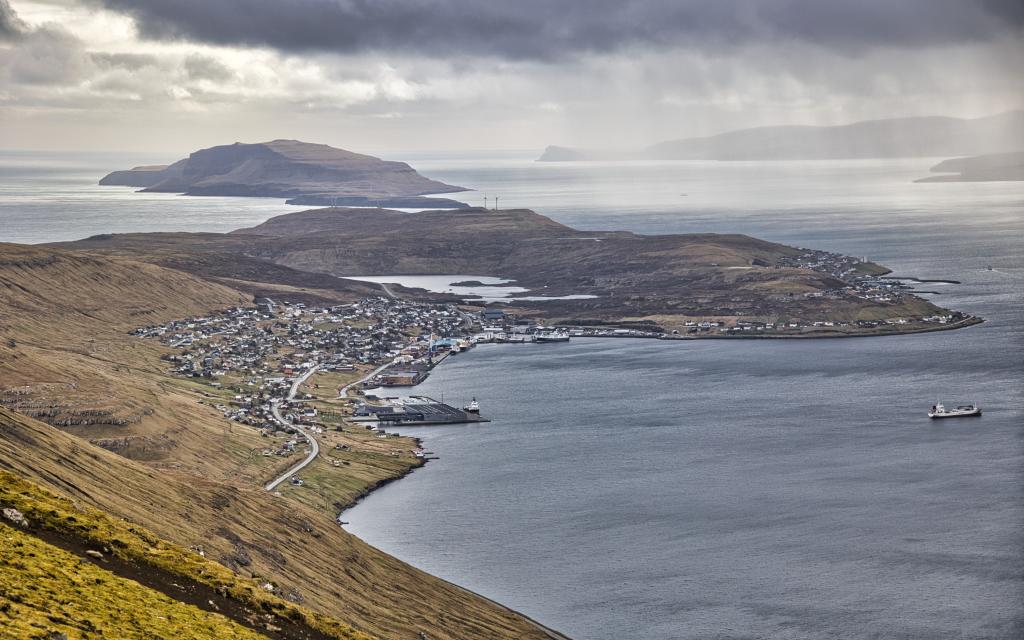
The western side of Støðlafjall gets plenty of sun and was once considered the best cattle grazing land in Eysturoy. The view becomes increasingly stunning, overlooking Skálafjørður, Gøtuvík, and Norðoyggjar. The steep Borgarin peak next to Nestindar is particularly striking.
The Summit and Historical Sites
At the top, countless mountains stretch into the distance, and the telecommunications mast stands here. The plateau is vast and was once used for football matches. Walk east along the ridge, but be cautious—it's steep! A British soldier fell to his death here during World War II.
The spectacular view over Syðrugøta is where the annual G! Festival takes place, and the distinctive round pier is visible. Below, in the valley known as Úti á Dalinum, peat was historically cut. A land dispute between Syðrugøta and Søldarfjørður led to this area being called Trætustykkið ("The Disputed Plot").
Legends of Tróndur and Skeggi
The path towards Miðafelsskarð is called Tróndargøta—the trail Tróndur í Gøtu used to walk to the assembly site under Stórafjall. Further south lies Skeggjanøvan, where, according to legend, a farmer named Søldi tricked his brother Skeggi and pushed him off the cliff.
Return
Walk south on the plateau to enjoy the view over Skálafjørður and Sandoy. Then head back north to the house and descend the same way you came up.


Gøtueiði - Støðlafjall - Gøtueiði
Gøtueiði - Støðlafjall - Gøtueiði
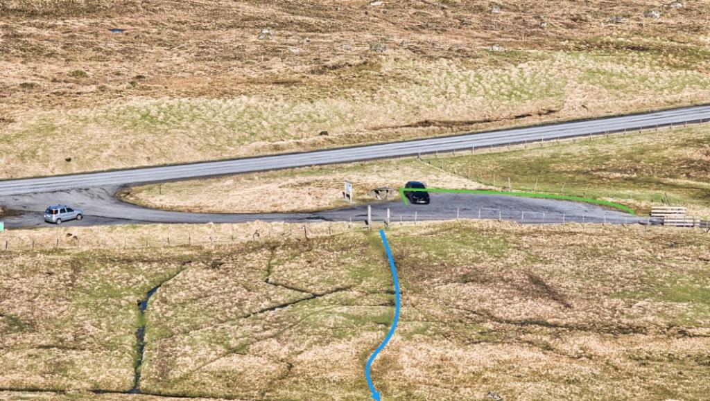
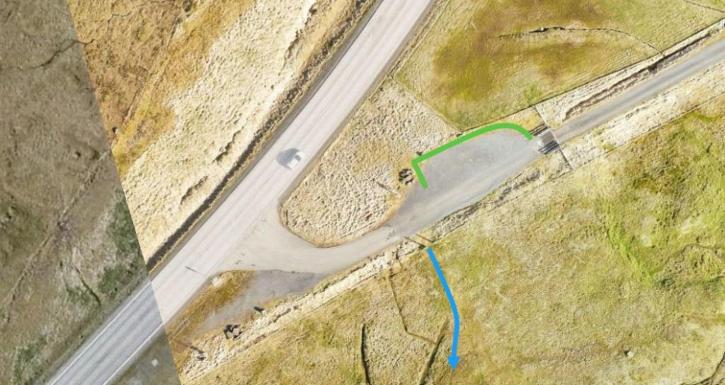
Parking, Gøtueiði:
There are good parking facilities at the large parking area on Gøtueiði – see the green lines. From there, follow the blue line and use the step ladder at the large gate to cross the fence.
There is no direct bus connection to Gøtueiði. The nearest bus stop is at the roundabout in Søldarfjørður/Skipanes, approximately 1.2 km away.
Bygdaleiðir:
400 Klaksvík – Tórshavn
401 Klaksvík – Tórshavn (Express)
Gøtueiði - Støðlafjall - Gøtueiði
Gøtueiði - Støðlafjall - Gøtueiði
The hike starts at the large parking area on Gøtueiði, where you walk through the gate. The path upwards follows the trail all the way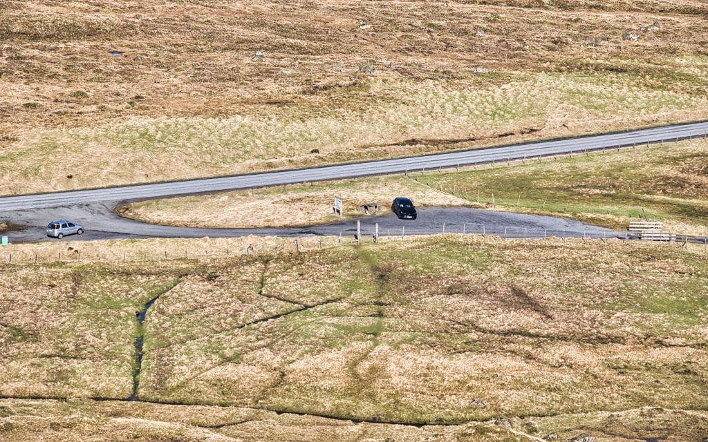
Facts

Duration

distance

Peak

Elevation
 6+, young children should be accompanied by adults due to the steep drops on the eastern side.
 Medium
- The trail is generally good and safe to walk. Some sections are steep and challenging. Through certain cliffs, caution is needed—depending on the weather
Medium
- The trail is generally good and safe to walk. Some sections are steep and challenging. Through certain cliffs, caution is needed—depending on the weather
 Mostly grassy and good terrain. Some wet areas at Hálsin. Loose ground near the top. Some wet, slippery rocks through the cliffs.
