


Tú hevur ongar yndis enn
Her kanst tú savna íblástur, greinar, tiltøk og støð, sum tú hevur áhuga fyri.
Trýst á ikonið á síðurnar, so koma tær fram her.
Tínir yndis
Íblástur & Greinir
Tiltøk & Túrar
Støð
Bygdagøtur
INSPIRATIÓNIR & ARTIKLAR
TILTØK & GONGUTÚRAR
Støð
Skálabotnur - Oyraskarð - Vesturdalur - Skálabotnur


Link Copied!

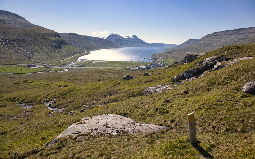


An extraordinary beautiful hike into another world hidden above the gorge Øksnagjógv, stretching into the fields called Millum Herðurnar – a beautiful, pleasant and tranquil place with good views.
From the sheepfold north of the church Keldan, take the large bridge crossing the river, and from there continue up to the hill Stórheyggur, on top of which you spot a cairn. From there, head straight up to the upper end of the gorge, from where you have a beautiful view down the gorge with the fiord Skálafjørður in the background. But be careful, it is steep and a long way down.
As soon as you are above the upper end of the gorge, it is as if you step into a different world. It turns quiet and tranquil. You come upon a charming river that runs smoothly down between the valley’s hillocks. Continue upwards along the river to the pass Høgukinnaskarð, where you have views out along Skálafjørður.
As you continue to ascend, all the way up to the pass Oyraskarð, good and large cairns guide your way. Along the path you can enjoy views over the fiord Funningsfjørður and the northern mountains of the isle of Eysturoy, including Slættaratindur, the country’s highest peak.
It is not difficult to conjure up the legend about Farmer Ormur (Adder), seeing him riding his horse across these wide, uninhabited plains. He was known for stealing sheep from the neighbouring farmers, the farmer of Funningur to the north and the farmer of Oyri to the west. His is only one of many stories told about the audacious sheep thieves roaming these plains and hills, including the one about Jákup Dintil of Syðrugøta.
Continue straight down into the valley Vesturdalur. When you draw near to the gorge Lokkafelsgjógv, there are two ledges you have to navigate down through. Especially the first one is steep in places. So be careful. And take your time to find one of the several easy routes down through it. It is advantageous to use the GPX file.
When you have reached Vesturdalur, follow the river that runs gently down to the riding path by the crag. Keep above the crag, turn to the right and continue south along the terrace Høgi Hvíthjalli. Here you will spot a few cairns, but they are not maintained, so several of them are no longer standing. It is easy to walk here, the terrain changing between being grass-covered and rocky. The view over the valley is lovely. When you come to the eastern end of the plain, you will see a small peaky hill by the river below you. It is called Stevnuválur and was the moot of the island of Eysturoy in ages past.
When you reach the east side of Mt. Rustin, descend down the steepest part. But do not go further down, stay on the same altitude, walking straight toward Skálafjørður. Keep above the farmer’s fence. The fence will lead you to the waterfall Tippafossur, below the gorge Øksnagjógv. It is recommended that you use the GPX file here.
The walk down to the high and lovely waterfall Tippafossur is beautiful and charming. From just above the large gorge Øksnagjógv, the brook runs through a deep gully down to the waterfall and into a deep pool, from which it eventually flows into the river Fjarðará. According to legend, it was here that the aforementioned Farmer Ormur hid the farmer from Oyri and his sons after he had killed them. He gave himself away while talking in his sleep, saying: “The clothes are found under the mill and the bodies under Tippafossur!” The farmhands heard this and found the bodies and the bloodied clothes. His case was heard at Stevnuválur, the moot mentioned above. He was sentenced to death. As the verdict was read, he ran away and was able to flee on his horse, heading toward the village of Skála. But after being pursued on both horseback and foot, he was caught, and his Achilles’ tendons were cut. On horseback he was returned to Stevnuválur, where he was executed and buried.
Continue on the last stretch, just above the hill Stórheyggur, and from there go down to the sheepfold by the large church Keldan in Skálafjørður, where you will find a bridge crossing the river. The gate is above the sheepfold.


Skálabotnur - Oyraskarð - Vesturdalur - Skálabotnur
Gott busssamband er í samb. við hendan rundtúrin. Skálafjørður eru eitt av høvuðs bussstoppistøðunum á leið 400 millum Tórshavn og Klaksvík. Fleiri lokalar bussleiðir koyra eisini kring Skálafjørðin.
Parkeringmøguleikar eru norðanfyri Kelduna – sí grønu markeringina.


Skálabotnur - Oyraskarð - Vesturdalur - Skálabotnur
Fakta

Tíð

longd

Hægsta stað

Hæddarmetrar
 10+
10+
 Miðal
-
Miðal
-
 Fyri tað mesta valla og gott lendi. Grýtut og vátt í støðum.
