WHAT'S ON


Language:


Sites
You haven’t got any favourites yet
This is where you can collect inspiration, articles, events and places that interest you.
Click the icon on pages and they’ll appear here.
Your favourites
Inspiration & Articles
Events & Tours
Places
Hiking
Search
Search results
INSPIRATION & ARTICLES
Read More
EVENTS & HIKES
Read More
Places
Read More
Argir - Kirkjubøur


Link Copied!

-
 On the trip there is a good chance that you will see some of the birds that breed in the field. This beautiful golden plover was just south of Rangagil. Photo: Óli Gardshodn
 -
 View from the tarn Klingrutjørn up towards the mountain Kirkjubøreyn. Photo: Óli Gardshodn
 -
 The view below the pass Álvaskarð towards the island of Nólsoy. Photo: Óli Gardshodn
 -
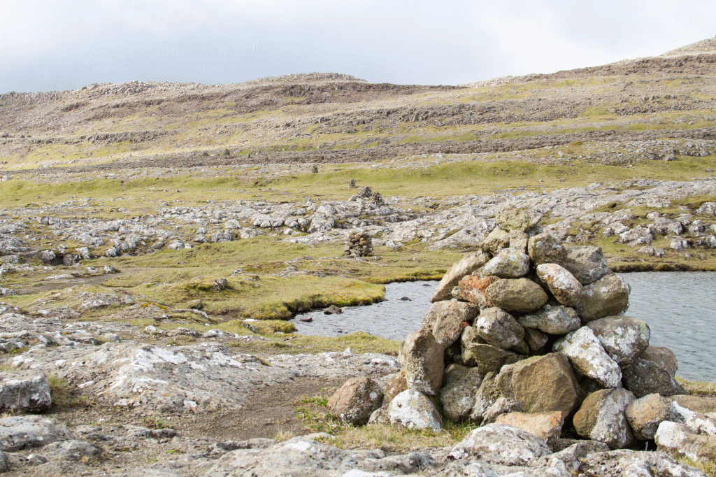
 Up by the tarn Porkerisvatn it is beautiful and cozy. This is a great place to enjoy the moment with a cup of coffee. Photo: Óli Gardshodn
 -
 View from the tarn Porkerisvatn towards the island Nólsoy. Photo: Óli Gardshodn
 -
 View south of the tarn Porkerisvatn, over the rill Rangagil and south on the mountain Kirkjubøkambur (306 m.), Which we see in the background to the left in the picture. The village path goes right south over the wide pass in the middle of the picture which is just above Kirkjubø. Photo: Óli Gardshodn
 -
 Up on the wide pass just above the village of Kirkjubø. Photo: Óli Gardshodn
 -
 View up from the wide pass over Kirkjubø west over the islands Koltur, to the left in the picture, and Koltur, to the right in the picture. Photo: Óli Gardshodn
 -
 Kirkjubøur. Photo: Óli Gardshodn
-
On the trip there is a good chance that you will see some of the birds that breed in the field. This beautiful golden plover was just south of Rangagil. Photo: Óli Gardshodn
-
View from the tarn Klingrutjørn up towards the mountain Kirkjubøreyn. Photo: Óli Gardshodn
-
The view below the pass Álvaskarð towards the island of Nólsoy. Photo: Óli Gardshodn
-
Up by the tarn Porkerisvatn it is beautiful and cozy. This is a great place to enjoy the moment with a cup of coffee. Photo: Óli Gardshodn
-
View from the tarn Porkerisvatn towards the island Nólsoy. Photo: Óli Gardshodn
-
View south of the tarn Porkerisvatn, over the rill Rangagil and south on the mountain Kirkjubøkambur (306 m.), Which we see in the background to the left in the picture. The village path goes right south over the wide pass in the middle of the picture which is just above Kirkjubø. Photo: Óli Gardshodn
-
Up on the wide pass just above the village of Kirkjubø. Photo: Óli Gardshodn
-
View up from the wide pass over Kirkjubø west over the islands Koltur, to the left in the picture, and Koltur, to the right in the picture. Photo: Óli Gardshodn
-
Kirkjubøur. Photo: Óli Gardshodn
Discover the scenic Argir - Kirkjubøur hike near Tórshavn, featuring unique terrain, birdwatching, and stunning views of Hestfjørð.
A quiet and beautiful walk with a slightly steep hike is just a short distance from Tórshavn. This unique and picturesque terrain offers a great view across Hestfjørð. On this route, you are likely to spot ground-nesting birds and hares.The path between Argir and Kirkjubø is the second route connecting Tórshavn and Kirkjubø, although it is less frequently used than the more common path that begins in Havnadal. However, this route remains important for those traveling from Kirkjubø to the hospital.
Much of this trail consists of gravelly terrain, making it difficult to see the path clearly. Therefore, we strongly recommend using a GPX file to help navigate and follow the track. While there are cairns along the route, it can be challenging to differentiate between the genuine cairns and misleading ones that could lead you off course.
This trip offers stunning and unique scenery, featuring rocky cliffs and a nearly moonlike landscape. You will walk past the beautiful Porkerisvatn (Porkeri’s Lake), where it's ideal to stop for a moment and appreciate the natural surroundings. It is said that William Heinesen, a renowned Faroese author and artist, drew inspiration for some of his sketches while exploring this area, Kirkjubøreyni. This region is believed to have inspired his troll drawings.


Argir - Kirkjubøur
Kirkjubøur - Argir
Argir - Kirkjubøur
There is excellent parking at Barnagarðin (nursery) in Argir—refer to the green lines. Once you are parked, reference the blue lines to indicate the start of the route.

Kirkjubøur - Argir
Excellent parking in the open area close to the harbour/church; from there, it is a 900-meter walk to the gate where the route starts – see the green line.

Argir - Kirkjubø
Kirkjubøur - Argir
Argir - Kirkjubø
Kirkjubøur - Argir
Facts

Duration

distance

Peak

Elevation
 Suitable for children. Slightly rocky and gravelly from Argir to Rangagil.
 Medium
- Much of the route is rocky and unclear, so a GPX file is essential. Cairns are present but unreliable, as some are “false” and off the original path.
Medium
- Much of the route is rocky and unclear, so a GPX file is essential. Cairns are present but unreliable, as some are “false” and off the original path.
 Easy to walk, gravelly in specific areas such as between Argir and Rangagil
