WHAT'S ON


Language:


Sites
You haven’t got any favourites yet
This is where you can collect inspiration, articles, events and places that interest you.
Click the icon on pages and they’ll appear here.
Your favourites
Inspiration & Articles
Events & Tours
Places
Hiking
Search
Search results
INSPIRATION & ARTICLES
Read More
EVENTS & HIKES
Read More
Places
Read More
Elduvík - Funningsfjørður - Elduvík


Link Copied!

-
 Elduvík village. Photo: @shawnogulu
 -
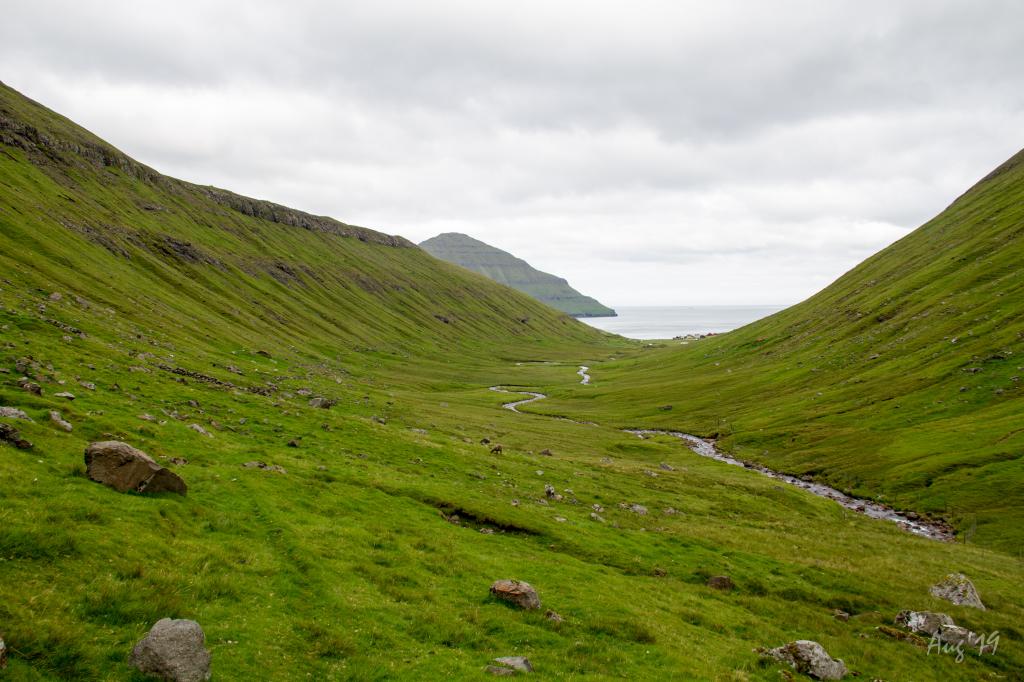 The long and very scenic valley up from the village Elduvík. Here you walk all by yourself between the high and rugged mountains. The only thing you hear is the sound of the river. In the background the village of Elduvík. Photo: Óli Gardshodn.
 -
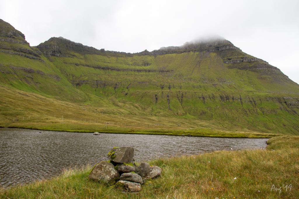
 The cairn and sheepfold under the gorge Øksnagjógv, in the valley of Elduvík. Photo: Óli Gardshodn
 -
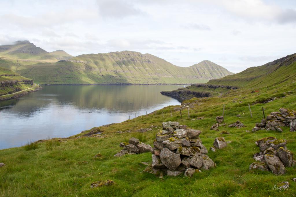
 Cairn at the small tarn called 'Tjørnin' at the pass above Funningsfjørður. In the background the mountain Múlatindur. Photo: Óli Gardshodn
 -
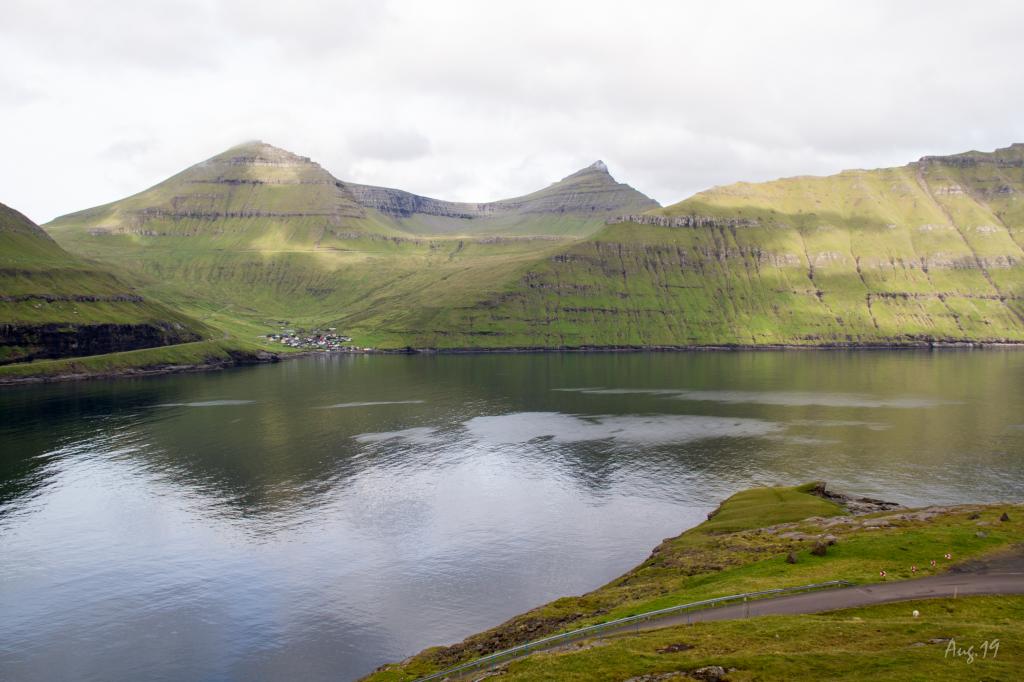
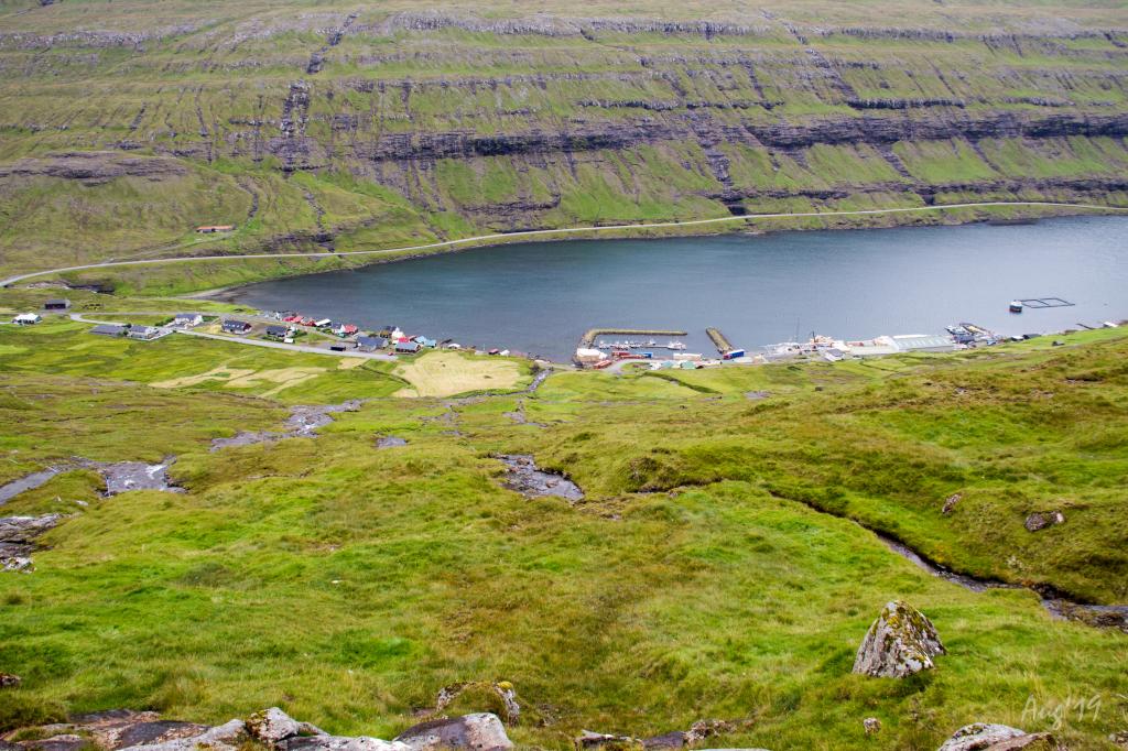 View of the village of Funningsfjørður. Photo: Óli Gardshodn
 -
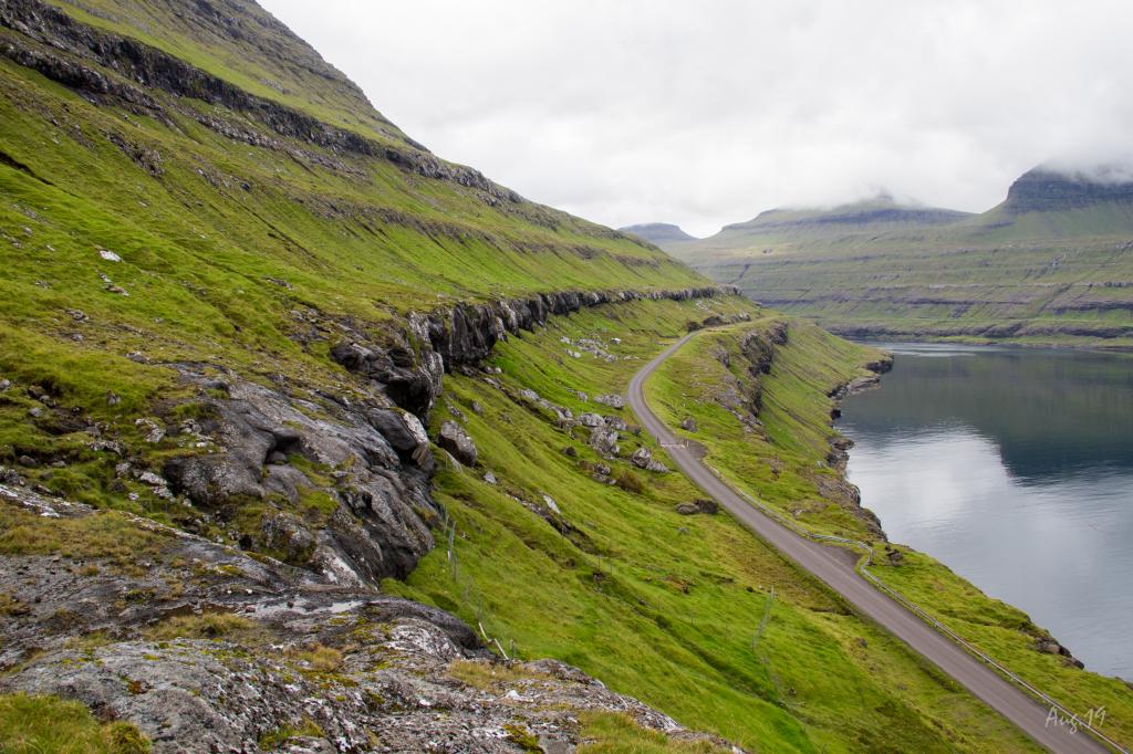
 The view north through the fjord Funningsfjørður. After walking the 60 altitude meters from the road up the mountain gorge Sniðsgil, we have reached the highest point on the village path. The rest of the trip to Elduvík is a 3km pleasant walk - except for a small slippage which we must cross. Photo: Óli Gardshodn
 -
 View from the headland Elduvíksnes into the fjord Funningsfjørður. The village path is all the way up on this rock wall that we stand on, and it goes as far in as we can see, after which it goes down the road through a mountain gorge. It is actually a very nice and quiet walk. Photo: Óli Gardshodn
 -
 View from the headland Elduvíksnes over to the village Funningur. In the background to the left the ridge up to the highest mountain on the Faroe Islands, Slættaratindur 882m., And to the right Gráfelli, the second highest mountain. Photo: Óli Gardshodn
 -
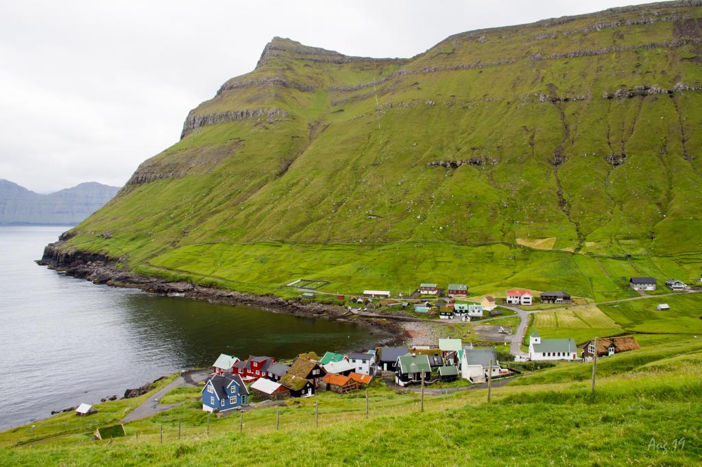 The village of Elduvík. Photo: Óli Gardshodn
-
Elduvík village. Photo: @shawnogulu
-
The long and very scenic valley up from the village Elduvík. Here you walk all by yourself between the high and rugged mountains. The only thing you hear is the sound of the river. In the background the village of Elduvík. Photo: Óli Gardshodn.
-
The cairn and sheepfold under the gorge Øksnagjógv, in the valley of Elduvík. Photo: Óli Gardshodn
-
Cairn at the small tarn called 'Tjørnin' at the pass above Funningsfjørður. In the background the mountain Múlatindur. Photo: Óli Gardshodn
-
View of the village of Funningsfjørður. Photo: Óli Gardshodn
-
The view north through the fjord Funningsfjørður. After walking the 60 altitude meters from the road up the mountain gorge Sniðsgil, we have reached the highest point on the village path. The rest of the trip to Elduvík is a 3km pleasant walk - except for a small slippage which we must cross. Photo: Óli Gardshodn
-
View from the headland Elduvíksnes into the fjord Funningsfjørður. The village path is all the way up on this rock wall that we stand on, and it goes as far in as we can see, after which it goes down the road through a mountain gorge. It is actually a very nice and quiet walk. Photo: Óli Gardshodn
-
View from the headland Elduvíksnes over to the village Funningur. In the background to the left the ridge up to the highest mountain on the Faroe Islands, Slættaratindur 882m., And to the right Gráfelli, the second highest mountain. Photo: Óli Gardshodn
-
The village of Elduvík. Photo: Óli Gardshodn
Experience the stunning Elduvík - Funningsfjørður - Elduvík roundtrip hike through dramatic valleys, waterfalls, and fjord views.
WARNING: A new landslide has made the hike back to Elduvík challenging.The village of Elduvík is situated by the sea at the end of a long green valley. Surrounded by high and steep mountains it is a beautiful and scenic place. The hike leads you up through the deep valley, which seems pleasant and inviting, with the Stórá River flowing gently through it. Halfway into the valley, you come to a sheepfold. Just above here you will find the large and deep Øksnagjógv gorge and just below you find the waterfall of Stórifossur. Further up the valley the Bláhamrar mountainside contrasts with the otherwise green valley. This is a great place to enjoy a cup of coffee along with the great views before embarking on the final stretch up to the pass. At this sheepfold, the herd that collects the sheep usually gathers when they plan the sheep drive. The walk by the riverbank on the way to Funningsfjørður is lovely. It is easy to walk the whole way from Elduvík to Funningsfjørður, although the drop is quite steep as you approach Funningsfjørður. The scenery in Funningsfjørður is stunning; the village is nestled between the two large fiords of the isle of Eysturoy. The village has been and still is a junction for traffic in the area, and the roads to the nearby villages are designated Buttercup Routes, scenic routes on particularly beautiful stretches. The first part of the hike from Elduvík to Funningsfjørður is 5.6 km long and takes about 2.5 hours. It is recommended to take a well-deserved break in the village of Funningfjørður and enjoy the views before heading back to Elduvík over the gully Sniðsgil. You will walk on the road the next 3.2 km to Funningsfjørður and further to Sniðsgil. As you enter Sniðsgil, you will hike up until you reach the crag Gøtuhjalli. From there, you continue to Gøtuhjalli, following the cairns down the sloping terraces to Elduvík. Some might find it difficult to walk across two small landslides above Barmur just east of Cape of Elduvík Along the fjord of Funningsfjørður, from Sniðsgil to Elduvík, the path goes just above the main road, which can cause noise from cars. The first cairn in Sniðsgil is visible from the road. The cairns are not visible from the village of Elduvík.


Elduvík - Funningsfjørður - Elduvík
Elduvík - Funningsfjørður - Elduvík
-
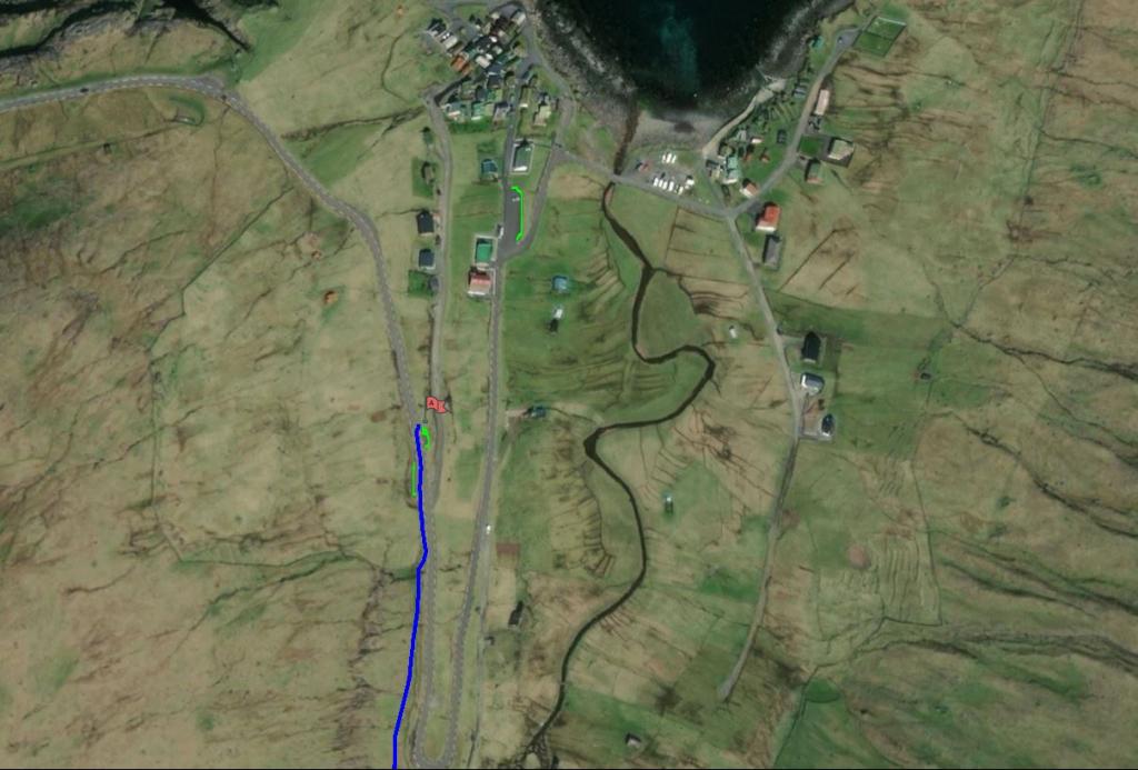 See green lines for parking and blue line for starting point
 -
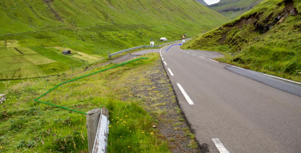 See green lines for parking and blue line for starting point
 -
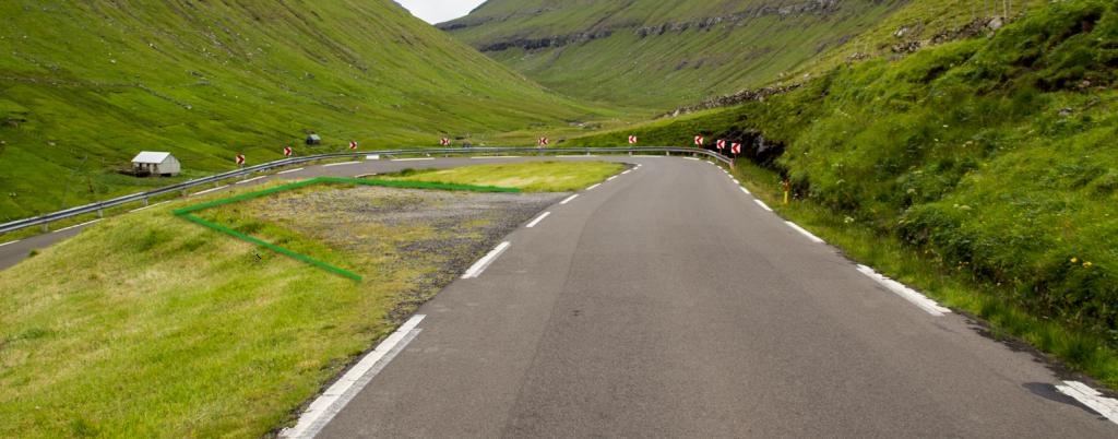 Green line indicates parking area
Elduvík - Funningsfjørður - Elduvík
Elduvík - Funningsfjørður - Elduvík
Facts

Duration

distance

Peak

Elevation
 Not suitable for children under the age of ten
 Difficult
- The entire path from Elduvík to Funningsfjørður is easy to walk, although it is steep in places, especially above Funningsfjørður. A somewhat long hike with a high elevation gain.
It is also easy to walk from Funningsfjørður til Elduvík through the gully of Sniðsgil, although at times steep, which might be a challenge for people with fear of heights
Difficult
- The entire path from Elduvík to Funningsfjørður is easy to walk, although it is steep in places, especially above Funningsfjørður. A somewhat long hike with a high elevation gain.
It is also easy to walk from Funningsfjørður til Elduvík through the gully of Sniðsgil, although at times steep, which might be a challenge for people with fear of heights
 The terrain is grass-covered and easy to walk, but wet in places and steep at times, especially near Funningsfjørður. The path is in bad condition in two gullies near the í Barmi neighbourhood of Elduvík. One must climb over a fence at the Cape of Elduvík
