WHAT'S ON


Language:


Sites
You haven’t got any favourites yet
This is where you can collect inspiration, articles, events and places that interest you.
Click the icon on pages and they’ll appear here.
Your favourites
Inspiration & Articles
Events & Tours
Places
Hiking
Search
Search results
INSPIRATION & ARTICLES
Read More
EVENTS & HIKES
Read More
Places
Read More
Klaksvík - Klakkur


Link Copied!

-
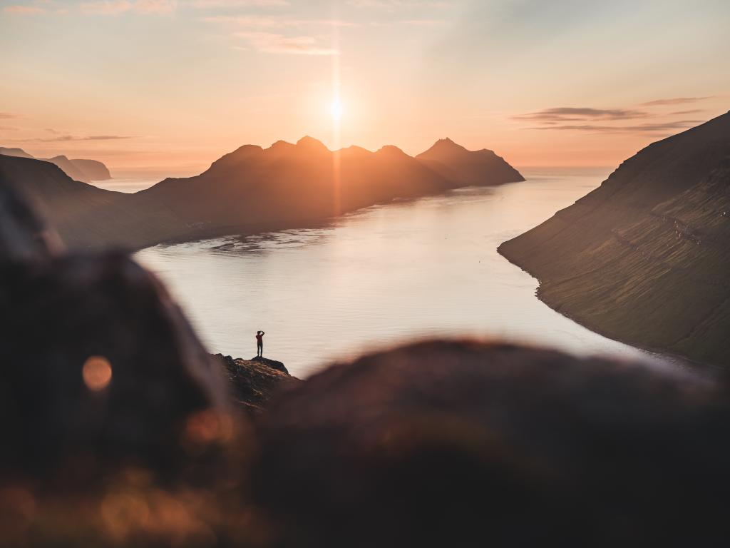 View from the mountain Klakkur north through the fjord Kalsoyarfjørður. On the left, the characteristic and special island of Kalsoy, with its 13 mountains.
 -
 The city of Klaksvík. The view from the road up to the mountain Klakkur – close to the river Vágsá. There are several small pieces of land that are fenced in, where some of the sheep are often fairly tame.. Photo: Óli Gardshodn.
 -
 The city of Klaksvík. View from the road Niðan Horn. Photo: Óli Gardshodn.
 -
 The view from the northern end of the mountain Klakkur south across the ridge and south towards the mountains Halgafelli and Háfjall. To the left is part of the town of Klaksvík. Photo: Óli Gardshodn.
 -
 On the way up the mountain Klakkur. In the middle of the picture, you can see the road we are going up, via the lake at the pass Hálsur. Photo: Óli Gardshodn.
 -
 View from the mountain Klakkur north through the fjord Kalsoyarfjørður. On the left, the characteristic and special island of Kalsoy, with its 13 mountains. Photo: Óli Gardshodn.
-
View from the mountain Klakkur north through the fjord Kalsoyarfjørður. On the left, the characteristic and special island of Kalsoy, with its 13 mountains.
-
The city of Klaksvík. The view from the road up to the mountain Klakkur – close to the river Vágsá. There are several small pieces of land that are fenced in, where some of the sheep are often fairly tame.. Photo: Óli Gardshodn.
-
The city of Klaksvík. View from the road Niðan Horn. Photo: Óli Gardshodn.
-
The view from the northern end of the mountain Klakkur south across the ridge and south towards the mountains Halgafelli and Háfjall. To the left is part of the town of Klaksvík. Photo: Óli Gardshodn.
-
On the way up the mountain Klakkur. In the middle of the picture, you can see the road we are going up, via the lake at the pass Hálsur. Photo: Óli Gardshodn.
-
View from the mountain Klakkur north through the fjord Kalsoyarfjørður. On the left, the characteristic and special island of Kalsoy, with its 13 mountains. Photo: Óli Gardshodn.
An easy, year-round trail offering stunning views over Kalsoy
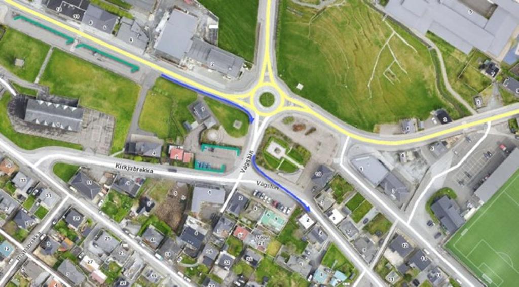
The route starts at the parking lot below the church in the centre of Klaksvík. Walk approximately 100-200 metres towards the roundabout. Turn right and walk 25-50 metres to Vágstún, then to the left about 600 metres along Uppsalagøta and then Nýggivegur. Turn right and continue along Oman Eið, approximately 500 metres before you reach the roundabout. Follow the road Niðan Horn about 400 metres. Turn right and enter a partially unpaved dirt road nicknamed Ástarbreytin (The love path). The gravel road continues all the way up to Hálsur. You can also drive up to Hálsur by car and park there. Note that the gravel road is somewhat uneven. Even though the path to Klakkur is not well marked, it is very easy to find. Standing at the outfield gate, head for the highest point north of you. There is also a cairn that you can see straight away and use as a landmark. Start walking through old peat fields. It is grassy all the way up to Klakkur with scarcely a single tiny stone. This is one of the few places where it is possible to ski in the winter. Many birds breed here: Oystercatcher, Arctic Skua, Snipe, Golden Plover, Whimbrel, and Lesser Black-Backed Gull. Ravens can also be seen, and Rock Pipits inhabit the remains of peat storages. In the valley just south of Hálsur is what the old folk called á Vaktini. Legend has it that people sat here watching out for hostile ships. When you have nearly come up the mountain and look down the west side, you can see Fagralíð. Fólkaháskúlin (Folk High School), which was founded in 1889, originally stood here until it was moved to Tórshavn. Símun av Skarði, a Faroese writer, poet and co-founder of Fólkaháskúlin, wrote the national anthem ”Tú alfagra land mítt” here in 1906. Be careful when you get to the top of Klakkur. It is very steep in some places. The view from the top is excellent. To the west, Leirvík, Gøtunes and Mjóvanes. Looking further south, you see Nólsoy if visibility is good. Kalsoy lies to the north like a long snake on the sea. For many years, the island’s nickname was “The Flute” because of the many tunnels. There are four villages on Kalsoy. Syðradalur is at the southern tip, and Húsar, Mikladalur, and Trøllanes are at the northern tip, which cannot be seen from Klakkur. People come to Mikladalur to see the statue of Kópakonan (Seal Woman), which is based on a local village legend. Kunoy is the tallest island in the country. There are six mountains over 800 metres. Eastwards, you see Haraldsund and Klaksvík spread out below. There were originally four villages here: Í Uppsølum, Í Gerðum, Á Myrkjanoyri and Í Vági. When you come down from Klakkur, you see Halgafelli ahead, then Háfjall. On the other side of Klaksvík, you see Myrkjanoyrafjall and Kjølin (The Keel), named so because it looks like the keel of an upturned boat. The route ends in the same place as it began.


Klaksvík - Klakkur
Klaksvík - Klakkur
The bus terminal in downtown Klaksvík, Við Sandin, is located at the start of the route.
Plenty of parking is available around the church in Klaksvík, as well as on Hálsaskarð, which is only 1,4 km from the viewpoint on Klakkur. However, the road conditions from Klaksvík to Hálsaskarð are quite rough.


Klaksvík - Klakkur
Klaksvík - Klakkur
Facts

Duration

distance

Peak

Elevation
 Suitable for children
 Medium
-
Medium
-
 First dirt road, then grass path
