


You haven’t got any favourites yet
This is where you can collect inspiration, articles, events and places that interest you.
Click the icon on pages and they’ll appear here.
Your favourites
Inspiration & Articles
Events & Tours
Places
Hiking
INSPIRATION & ARTICLES
EVENTS & HIKES
Places
Norðoyri - Skúvadalur


Link Copied!

-
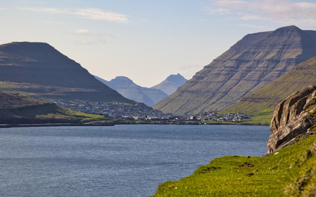 The view from the path below Núpsrøkur, south of the village of Norðoyri, over Klaksvík. To the left is the mountain Klakkur, and to the right is the mountain Suður á Nakki on the island of Kunoy. In the background are the mountains Gásafjall and Nestindar on the island of Kalsoy. Photo: Óli Gardshodn.
 -
 The stone Klovningasteinur, by the rock face Byrgishamar, below the Torvadalur valley. Photo: Óli Gardshodn.
 -
 Lake Vatnið við Hólminum. Photo: Óli Gardshodn.
 -
 The particularly good view just below lake Vatnið við Hólminum, south towards Tórshavn. On the left is the island of Nólsoy. In the middle the headlands Mjóvanes, Nev and Eystnes. To the right the headland Borðoyarnes. Photo: Óli Gardshodn.
 -
 The view from the helipad down over the Scout House in the Skúvadalur valley. Photo: Óli Gardshodn.
 -
 The headlands Mjóðanes, Nev and Eystnes. To the right, the promontory of Borðoyarnes. In the background Tórshavn. Photo: Óli Gardshodn.
 -
 At the end of the road south of Norðoyri, where you continue onto the path south towards the Skúvadalur valley. Do you see the spew? Especially at the beginning of the trip, there was a lot of wildlife – sheep and birds, which just made the trip a little more pleasant. Photo: Óli Gardshodn.
-
The view from the path below Núpsrøkur, south of the village of Norðoyri, over Klaksvík. To the left is the mountain Klakkur, and to the right is the mountain Suður á Nakki on the island of Kunoy. In the background are the mountains Gásafjall and Nestindar on the island of Kalsoy. Photo: Óli Gardshodn.
-
The stone Klovningasteinur, by the rock face Byrgishamar, below the Torvadalur valley. Photo: Óli Gardshodn.
-
Lake Vatnið við Hólminum. Photo: Óli Gardshodn.
-
The particularly good view just below lake Vatnið við Hólminum, south towards Tórshavn. On the left is the island of Nólsoy. In the middle the headlands Mjóvanes, Nev and Eystnes. To the right the headland Borðoyarnes. Photo: Óli Gardshodn.
-
The view from the helipad down over the Scout House in the Skúvadalur valley. Photo: Óli Gardshodn.
-
The headlands Mjóðanes, Nev and Eystnes. To the right, the promontory of Borðoyarnes. In the background Tórshavn. Photo: Óli Gardshodn.
-
At the end of the road south of Norðoyri, where you continue onto the path south towards the Skúvadalur valley. Do you see the spew? Especially at the beginning of the trip, there was a lot of wildlife – sheep and birds, which just made the trip a little more pleasant. Photo: Óli Gardshodn.
Discover the Norðoyri - Skúvadalur hike: a scenic 8 km trail with rich history, wildlife, and stunning island views.
The hike starts south of the cattle grid in Norðoyri, an ancient village. Archaeological evidence suggests that people have lived here since the Viking era.
From the parking walk some 600 metres south on a dirt road that suddenly ends by a large cairn. From here, go upwards and follow path of gravel and loose rocks. This steep is short and from here the path is grassy and even, but clearly visible from foot and horse traffic. Before the valley of Skúvadal the path fades away and becomes grassy. Poles guide you along the final stretch to the newly built scout house.
On clear days you can see all the way to Suðuroy, the southernmost island, as well as Lítli Dímun, the smallest island. When you arrive in the scout house you can sit on the bench and enjoy a meal. The house was originally built in 1941 by some 20 people from Klaksvík for recreational purposes. In 1949 the local scout group got rights to use the house. In 2016 the old and dilapidated house was demolished and a new was built on the same spot. The house was built by the lumber department at the technical collage in Klaksvík, and from carried by helicopter to Skúvadal in parts.
Many lakes are some 600 metres east of the house. You might be lucky to see the rare red-throated loon, but be respectful an careful so as to not disturb the precious eco systems. Walk the same way back home.


Norðoyri
Plenty of parking spaces are south of the cattle gate, see the green line. From here go through the gate - see the blue line.
GG: If many cars are parked it may be because of sheep herding. This happens 4 times each year and we encourage visitors to stay away on these dates. If in doubt please as a local or the local information centre in Klaksvík.


Norðoyri
Facts

Duration

distance

Peak

Elevation
 8 +
8 +
 Medium
- The path is mostly level and easy to walk, but gets a quite steep in places.
Medium
- The path is mostly level and easy to walk, but gets a quite steep in places.
 Grassy and easy to hike. Some gravel and loose rocks in places and steep in places.
