


You haven’t got any favourites yet
This is where you can collect inspiration, articles, events and places that interest you.
Click the icon on pages and they’ll appear here.
Your favourites
Inspiration & Articles
Events & Tours
Places
Hiking
INSPIRATION & ARTICLES
EVENTS & HIKES
Places
Norðtoftir - Klaksvík


Link Copied!

-
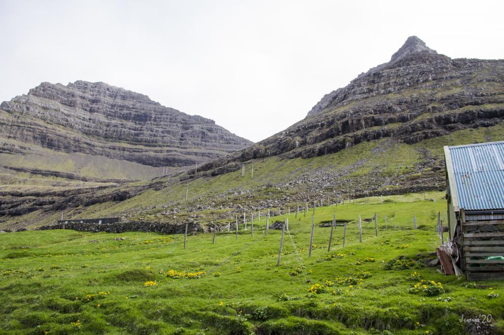 The route from the sheepfold in the village Norðtoftir, up into the valley between the mountains Krúnufjall and Toftaknúkur, to the left and right side respectively in the picture. Photo: Óli Gardshodn
 -
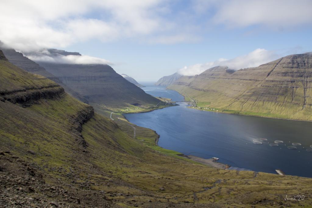 As you walk up through the Toftadalur valley, which lies above the village of Norðtoftir, you have a stunning view north through Hvannasund. Photo: Óli Gardshodn
 -
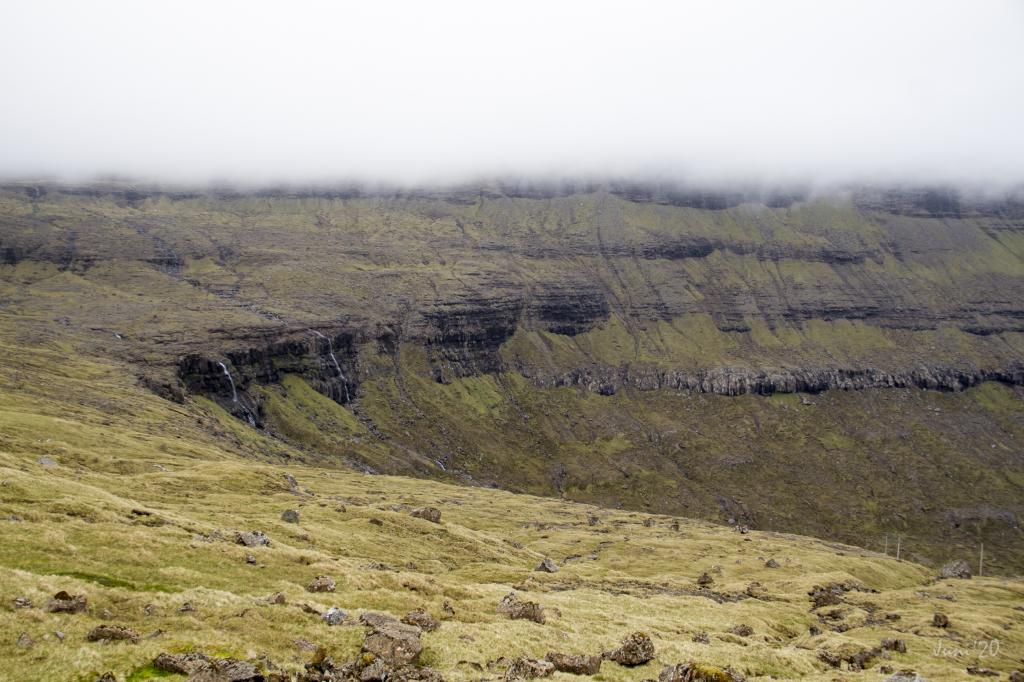
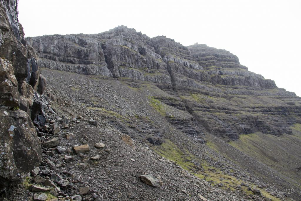 It is knotty and strenuous to walk up the steep valley to the pass Toftaskarð through all the loose stones. Photo: Óli Gardshodn
 -
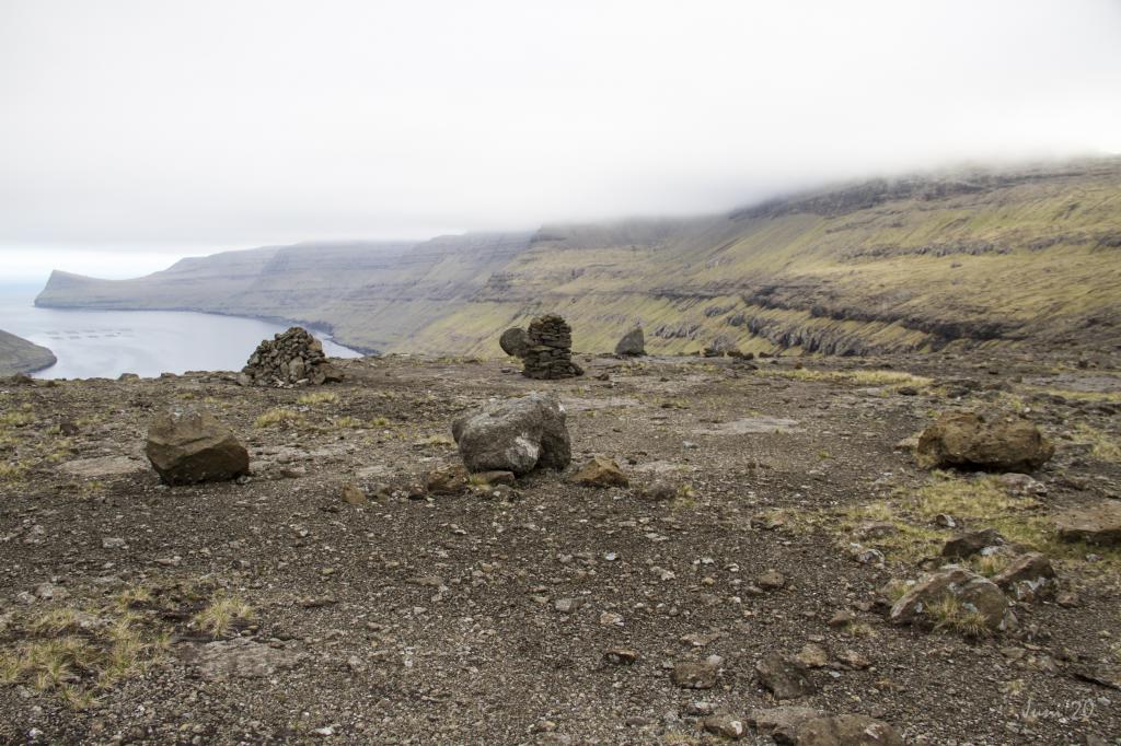 Katlarnir - the ancient thingstead of the Northern Isles. Photo: Óli Gardshodn
 -
 To the left between the two rivers, Katlarnir - the ancient thingstead of the Northern Isles. Photo: Óli Gardshodn
 -
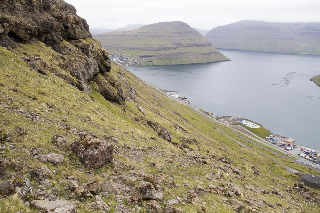 The descent from the pass Áarskarð. Here we are under the rock wall at Hvítabrúgv. In the background to the right we see Klaksvík appear. Photo: Óli Gardshodn
 -
 The old peatlands north of Klaksvík, where there are many birds. Here we see a Golden Plover (Pluvialis apricaria) - a threatened species. Photo: Óli Gardshodn
-
The route from the sheepfold in the village Norðtoftir, up into the valley between the mountains Krúnufjall and Toftaknúkur, to the left and right side respectively in the picture. Photo: Óli Gardshodn
-
As you walk up through the Toftadalur valley, which lies above the village of Norðtoftir, you have a stunning view north through Hvannasund. Photo: Óli Gardshodn
-
It is knotty and strenuous to walk up the steep valley to the pass Toftaskarð through all the loose stones. Photo: Óli Gardshodn
-
Katlarnir - the ancient thingstead of the Northern Isles. Photo: Óli Gardshodn
-
To the left between the two rivers, Katlarnir - the ancient thingstead of the Northern Isles. Photo: Óli Gardshodn
-
The descent from the pass Áarskarð. Here we are under the rock wall at Hvítabrúgv. In the background to the right we see Klaksvík appear. Photo: Óli Gardshodn
-
The old peatlands north of Klaksvík, where there are many birds. Here we see a Golden Plover (Pluvialis apricaria) - a threatened species. Photo: Óli Gardshodn
Norðtoftir - Klaksvík offers a challenging hike along an old mountain village path, visiting historic Katlarnir moot site.
The hike starts just east of Norðtoftavegur 10, where you take the short stretch up to the sheep pen and continue for about 150 metres uphill, where you cross a fence to reach the village path that leads you up to the valley Toftadalur. From there, you continue up to the pass Toftaskarð.
When walking up to Toftaskarð, keep to the east side, just east of the big scree that comes down the whole pass. The path is grass-covered in the area Sjøt and all the way up toward the pass. When you are right under the pass, walk just beneath the crag all the way up the Toftaskarð.
Toftaskarð is full of rock of all sizes, making it cumbersome to walk through. Be careful to keep rocks from rolling down on other hikers.
From Toftaskarð, walk straight toward Katlarnir, down through the pass Upp á Gjógv.
At the moot Katlarnir, the men of the Northern Isles met in spring for the spring session. The terrain is even, and bedrock surrounds the large boulder Tingsteinurin (The Moot Boulder).
At Katlarnir, the ground is even with quite a bit of bedrock, with several rocks laying around the boulder, Tingsteinurin. It is easy to imagine that these rocks have played one role or another when moots where held here in ages past.
Leaving Katlarnir, climb over the fence, go straight up to the pass Áarskarð. From there, walk down through the upper part of the gorge Ánagjógv, then turn south by a lone cottage toward Klaksvík, where you descend to the infield gate just above Undir Kráarbrekka 21, also known as Rynkeby.
The path can be taken in either direction.


Norðtoftir - Klaksvík
Public transport
Route 500 drives between Klaksvík and Hvannasund.
Route 400 drives between Tórshavn and Klaksvík.
Arriving by car
Parkin, Norðtoftir
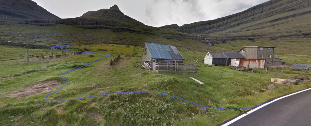
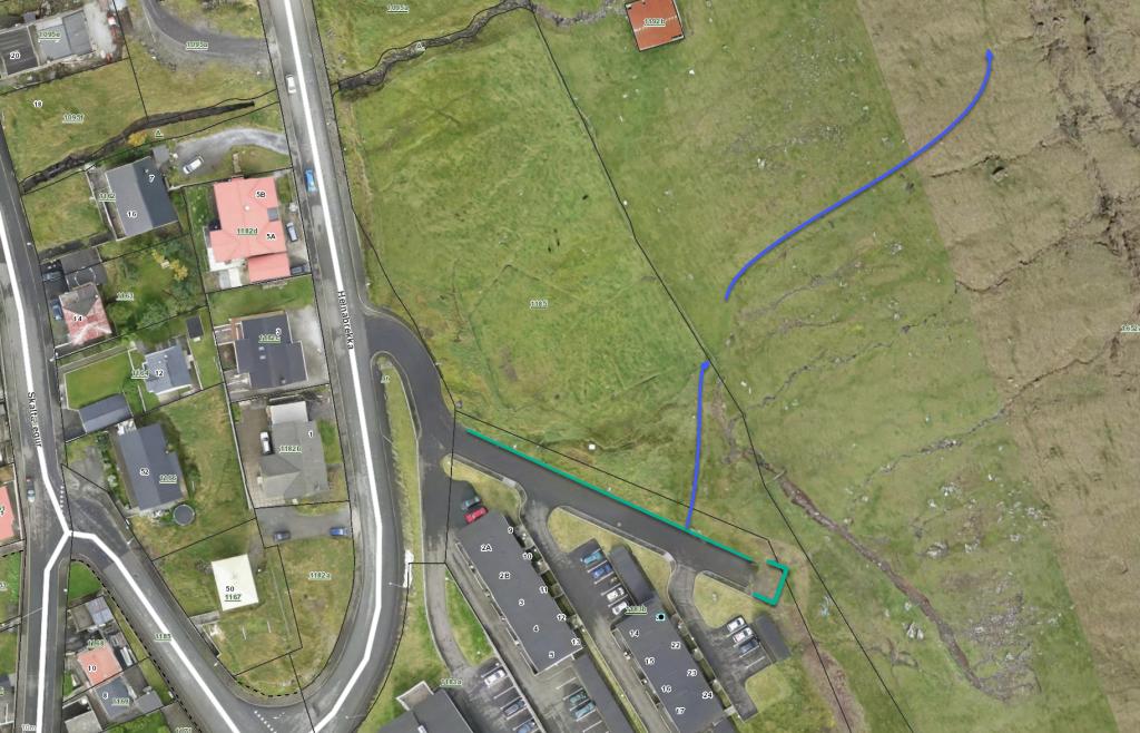
At Norðtoftir, park your car about 200 metres west of Norðtoftavegur 10 – see the green lines. From there, follow the blue lines up to the sheep pen and ascend for about another 120 metres until you reach the old village path.
-
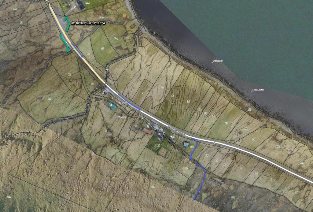 green line: parking, blue line: starting point
 -
 green line: parking, blue line: starting point
 -
 starting point
Klaksvík - Norðtoftir
Public transport
Route 500 drives between Klaksvík and Hvannasund.
Route 400 drives between Tórshavn and Klaksvík.
Arriving by car
Parking, Klaksvík
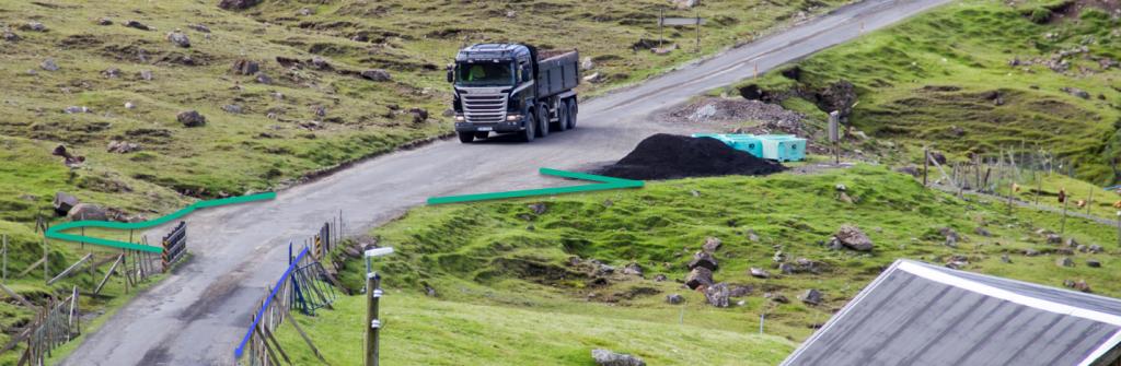
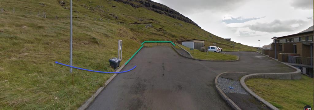
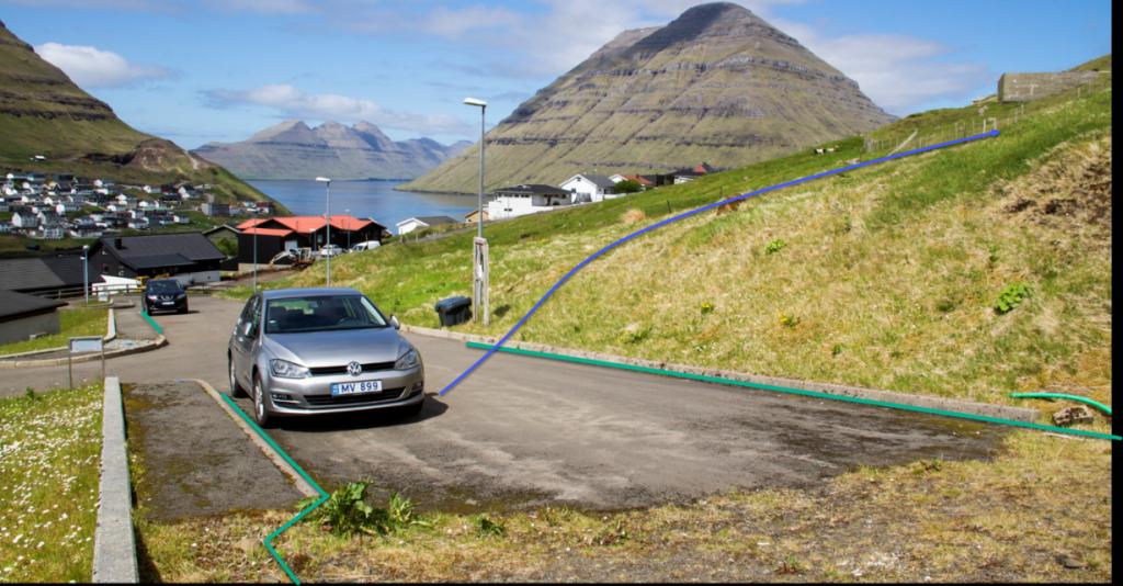
Parking is available at the end of Kráarbrekka in Klaksvík by the infield gate—see the green lines. From there, walk to the infield gate.
-
 green line: parking, blue line: starting point
 -
 green line: parking, blue line: starting point
 -
 starting point
Norðtoftir - Klaksvík
Klaksvík - Norðtoftir
Facts

Duration

distance

Peak

Elevation
 The hike is not suited for kids under 14 years. In places, a lot of loose rock, where it is easy to get scraped
 Difficult
- The hike is quite long. The particularly steep and challenging parts are found up through the upper part of Toftaskarð and from Tólvmarkaknúkur down through the pass Uppi á Gjógv
Difficult
- The hike is quite long. The particularly steep and challenging parts are found up through the upper part of Toftaskarð and from Tólvmarkaknúkur down through the pass Uppi á Gjógv
 From an elevation of about 300 metres and all the way up to Toftaskarð (466 m) it is very rocky, including very large boulders. The path has loose rocks down from Tólvmarkaknúkur down toward Uppi á Gjógv as well as at Áarskarð.
It is steep in places, including in Toftaskarð and Uppi á Gjógv.
Otherwise, the terrain is grass-covered and good for walking.
From an elevation of about 300 metres and all the way up to Toftaskarð (466 m) it is very rocky, including very large boulders. The path has loose rocks down from Tólvmarkaknúkur down toward Uppi á Gjógv as well as at Áarskarð.
It is steep in places, including in Toftaskarð and Uppi á Gjógv.
Otherwise, the terrain is grass-covered and good for walking.
