


You haven’t got any favourites yet
This is where you can collect inspiration, articles, events and places that interest you.
Click the icon on pages and they’ll appear here.
Your favourites
Inspiration & Articles
Events & Tours
Places
Hiking
INSPIRATION & ARTICLES
EVENTS & HIKES
Places
Runavík - Rituvík


Link Copied!

-
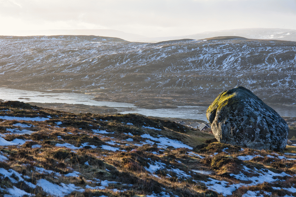 On the way up from the village of Runavík to the pass towards Rituvík, called Innarihálsur, the view is beautiful down on the lake Toftavatn - the fourth largest lake in the Faroe Islands. Picture: Óli Gardshodn
 -
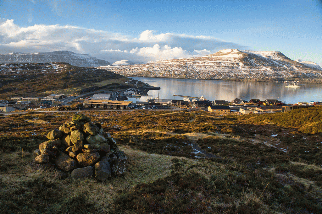 View down over Runavík. Picture: Óli Gardshodn
 -
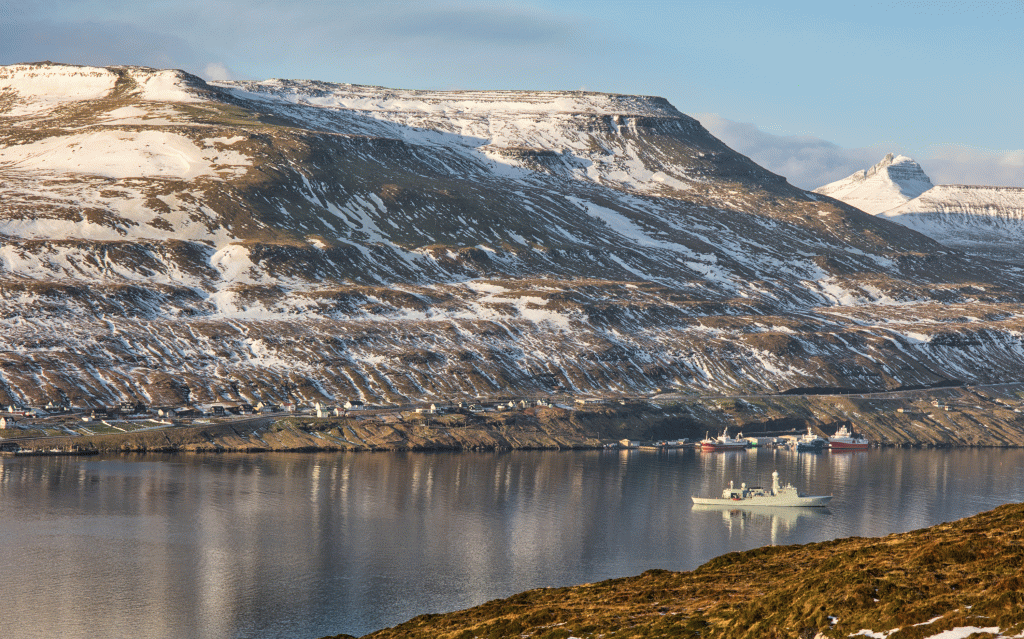 View from the pass Innarihálsur over to the place Hulkur in the village Strendur. Picture: Óli Gardshodn
 -
 View from the pass Innarihálsur. It is up here that the water spring is said to provide water to both settlements, Runavík and Rituvík. Picture: Óli Gardshodn
 -
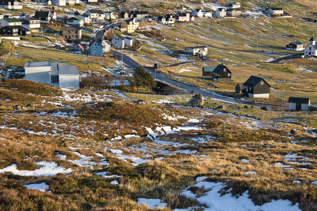
 On the path from the village Runavík down to the village Rituvík. Picture: Óli Gardshodn
 -
 On the path from the village Runavík down to the village Rituvík. The village gate is along the river Stórá, by the big white house on the left in the picture. Picture: Óli Gardshodn
 -
 The village gate in Rituvík on the path to the village Runavík. Picture: Óli Gardshodn
-
On the way up from the village of Runavík to the pass towards Rituvík, called Innarihálsur, the view is beautiful down on the lake Toftavatn - the fourth largest lake in the Faroe Islands. Picture: Óli Gardshodn
-
View down over Runavík. Picture: Óli Gardshodn
-
View from the pass Innarihálsur over to the place Hulkur in the village Strendur. Picture: Óli Gardshodn
-
View from the pass Innarihálsur. It is up here that the water spring is said to provide water to both settlements, Runavík and Rituvík. Picture: Óli Gardshodn
-
On the path from the village Runavík down to the village Rituvík. Picture: Óli Gardshodn
-
On the path from the village Runavík down to the village Rituvík. The village gate is along the river Stórá, by the big white house on the left in the picture. Picture: Óli Gardshodn
-
The village gate in Rituvík on the path to the village Runavík. Picture: Óli Gardshodn
Discover the scenic Runavík - Rituvík hike: an easy 2 km walk through vibrant heather with stunning views over Toftavatn lake.
This path is suitable for a short trip up to Innaraháls or over to Rituvík or ideal as the start of a 9.5km round hike of Runavík – Rituvík – Toftir – Runavík (find this route on bygdagøtur. fo).
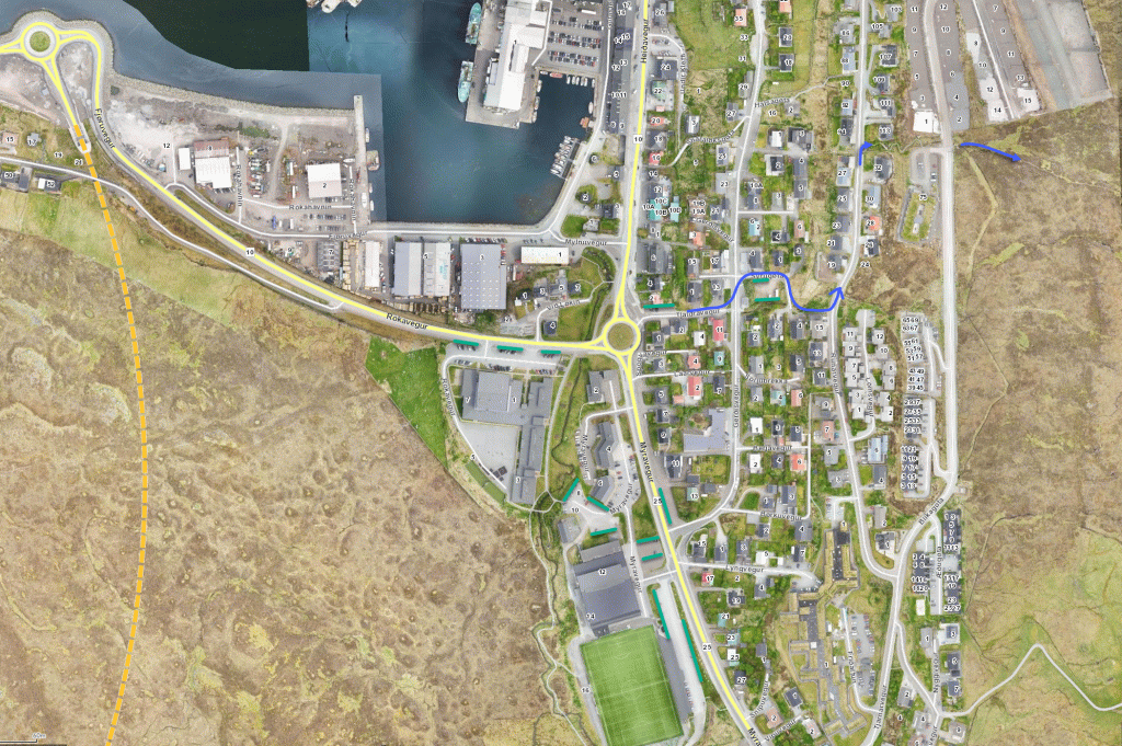
You will start down by Skúlan við Løkin in Runavík, where there is decent parking. Then walk up the shortcut through town to the houseshare at Blikagøta 75, just above the gate, which leads you out the path towards Rituvík.
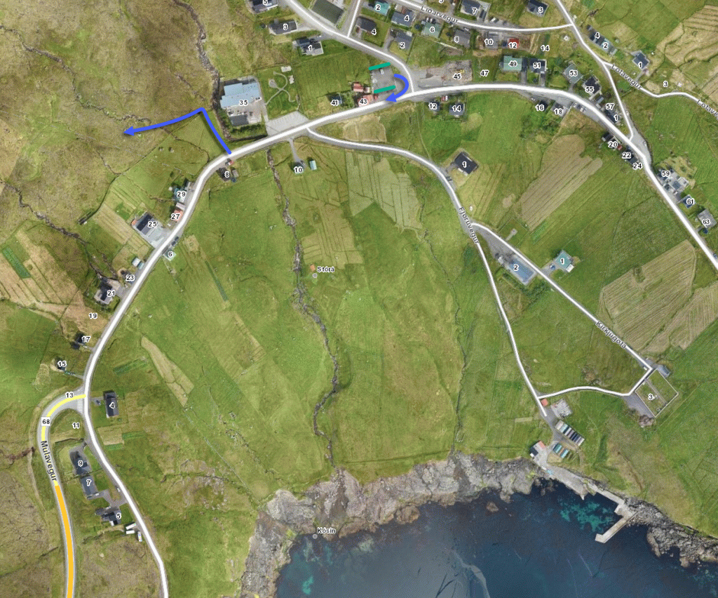
It is nice and cosy to walk up the path, making its way through the heather. The cairns, which stand close to each other up on the south side of the brook, appear one by one as you walk the route across Innaraháls. On the way up the neck is a green field called Hvílingarfløtan. In this field, which is always said to be green, villagers would put down their wooden creel and rest. After the men from Rituvík returned from fishing, the village women would take and carry the fish back to Runavík, and they would bring other food products on the way back home.
Spring is on top of Hálsi and runs down both ways, meaning it runs half to Runavík and half to Rituvík. Just south of Halsi, there are also two small lakes.
The view is excellent on this flat land. You will be able to see over Toftavatn, the mountains east of Skálafjørð and Streymoy.
Once you have arrived east of the neck, you then change to walk on the north side of the stream. In Grøv, the stream becomes deep and spectacular; here, stepping down in the stream was also normal. Down to Rituvík, the terrain is quite peaty with lots of heathers. It can be challenging to see the cairns as some are small, but they are there, and you simply have to look hard enough.
When you arrive at the stone wall, walk down by Stórá, where the stone gate is.


Runavík - Rituvík
440 Skálafjarðarleiðin: https://www.ssl.fo/fo/ferdaaetlan/bygdaleidir/440-skalafjardarleidin/
442 Glyvrar – Æðuvík – Rituvík: https://www.ssl.fo/fo/ferdaaetlan/bygdaleidir/442-glyvrar-aeduvik-rituvik/
444 Kambsdalur - Skálafjørður/Toftir: https://www.ssl.fo/fo/ferdaaetlan/bygdaleidir/444-kambsdalur-skalafjordur-toftir/
4
Rituvík - Runavík
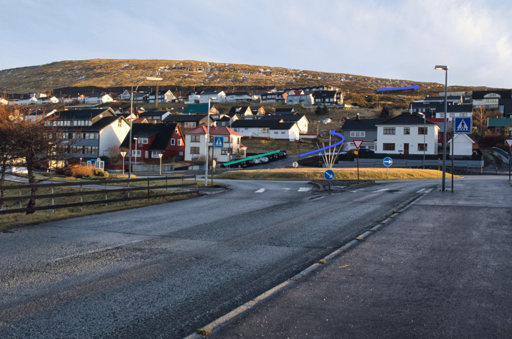
Park on the parking space where the old school used to be just east of Rituvíkarvegur 43—refer to the green markings. From there, follow the blue lines in the image.

Facts

Duration

distance

Peak

Elevation
 Yes.
Yes.
 Medium
-
Medium
-
 Grassy with lots of heathers.
On the Rituvík side, it is slightly uneven, peaty, and wet in areas.
By the stream in Grøv, the terrain is a bit steep but not significantly high.
Grassy with lots of heathers.
On the Rituvík side, it is slightly uneven, peaty, and wet in areas.
By the stream in Grøv, the terrain is a bit steep but not significantly high.
