


You haven’t got any favourites yet
This is where you can collect inspiration, articles, events and places that interest you.
Click the icon on pages and they’ll appear here.
Your favourites
Inspiration & Articles
Events & Tours
Places
Hiking
INSPIRATION & ARTICLES
EVENTS & HIKES
Places
Skarvanes - Dalur


Link Copied!


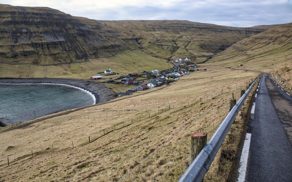

Experience the Skarvanes - Dalur hike, a scenic 5 km trail on Sandoy linking charming villages with stunning coastal and island views.
The hike starts by the river in the middle of the village, where you find the old watermill. The mill, which is a listed structure, was used to grind grain in times past. There are two roads in the village. Take the high road and soon you find yourself on the cairn path that slopes upward in a southern direction.
Enjoy the sound of waves hitting the bedrock below the path while looking out to the isle of Skúvoy, where Sigmund Brestisson lived and was buried. Brestisson, renowned from the Faroese Saga, was the chieftain who Christianised the Faroes by force around AD 1000.
To the south you will find the islands Stóra Dímun and Lítla Dímun. In that direction you also see the northern end of the isle of Suðuroy, including Mt. Borgin by the village Sandvík.
Flotsam Eldorado
Skarvanes has always been a small village. It was one of the country’s best places to grow grain. But it was not good for going out fishing because of frequent heavy surfs. However, the village was great for flotsam, especially the bay Suggan was renowned for drawing flotsam in.
Díðrikur á Skarvanesi (1802-1865), also known as Díðrikur of Kárastova, lived here. He is known as the first painter in the Faroes. Some of his unique bird illustrations have survived and can be viewed at the National Gallery of the Faroe Islands.
When you have hiked for about 700 metres, you walk up a ledge with a fairly steep drop. But just be careful and it is easy to walk.
The path slopes gently upwards in a southernly direction and is well marked with posts and cairns. When you have walked just over a kilometre you come up to Mt Gjófelli, where a unique and beautiful sight awaits you—wide plains and pleasant pools and lakes.
Continue up to the cairn called Handastavarði. By now you are halfway through your hike. The hike is level here, and when visibility is good, you see all the way to the isle of Mykines and the islet Mykineshólmur in the east.
The wide plains up here are impressive. The outfields, especially Skorin to the south, are good for raising sheep, partly due to the many puffins that fertilise them.
When you have hiked a little more than three kilometres, you will see Dalur in the distance. Dalur is the southernmost village in Sandoy. The village has been very isolated, not reachable by road before 1963. Therefore, the cairn paths to the neighbouring villages of Húsavík and Skarvanes have been vital.
Going through a very steep hill, the current road between Dalur and Húsavík is often impeded by fallen rocks and landslides. In 2020, the first blast for a new tunnel between the villages was detonated.
When you have reached the last cairn, take the road down into the village. This is the old peat road that was constructed in the late 1930s. The villagers cut peat up in the hills near the outfield known as Skorin and used the road to lug it back on horseback. Today, this road is mostly used when tending to sheep.
When you have reached level ground, look up to the hills to see the beautiful rock walls that surround the village.
The Faroese chain dance is alive and well in Dalur, and has the village fostered many a great chanter. The village church was consecrated in 1957, making it one of the newer churches in the Faroes. Before the church was built, the villagers went to Húsavík to go to church.
Down at the pebble beach, the pebbles are both unique and beautiful, and a deep rumble is heard when the surf wells over them. It is illegal to take pebbles from the beach, as the beach protects the village from the winter surfs.


Skarvanes - Dalur
Fairly good parking is to be found in the new parking place by the school in Skarvanes. It takes a few cars.
Park within the green lines and follow the blue line when starting your hike.


Dalur - Skarvanes
You will find good parking down in the village of Dalur, by Eiriksgarður, the village hall.
Park by the green lines and follow the blue line to commence your hike. When you have walked for about 1.3 kilometres up the gravel road (to an altitude of about 125 metres), you will see a Visit Faroe Islands sign and signposts leading you to the path.
Park within the green lines and follow the blue line to begin your hike.


Skarvanes - Dalur
Dalur - Skarvanes
Facts

Duration

distance

Peak

Elevation
 Yes, 8+.
 Medium
-
Medium
-
 Grass-covered cairn path with gravelly patches. The last stretch down to the village of Dalur is on a gravel road.
