


You haven’t got any favourites yet
This is where you can collect inspiration, articles, events and places that interest you.
Click the icon on pages and they’ll appear here.
Your favourites
Inspiration & Articles
Events & Tours
Places
Hiking
INSPIRATION & ARTICLES
EVENTS & HIKES
Places
Sundshálsur - Syðradalur - Norðradalur - Sundshálsur


Link Copied!

-
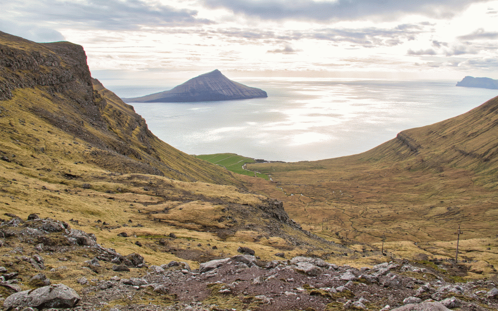 View from the pass Reiðskarð (419 m.) down on the valley Syðradalur. Picture: Óli Gardshodn
 -
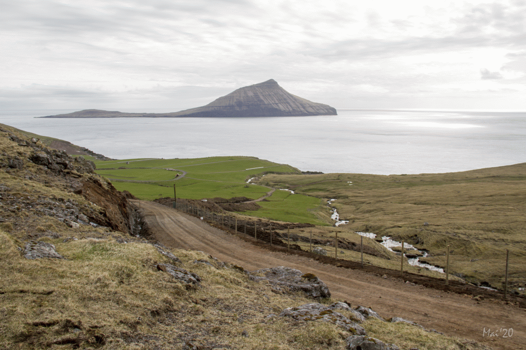 The northern part of the valley Syðradalur. In the background the island of Koltur. Picture: Óli Gardshodn
 -
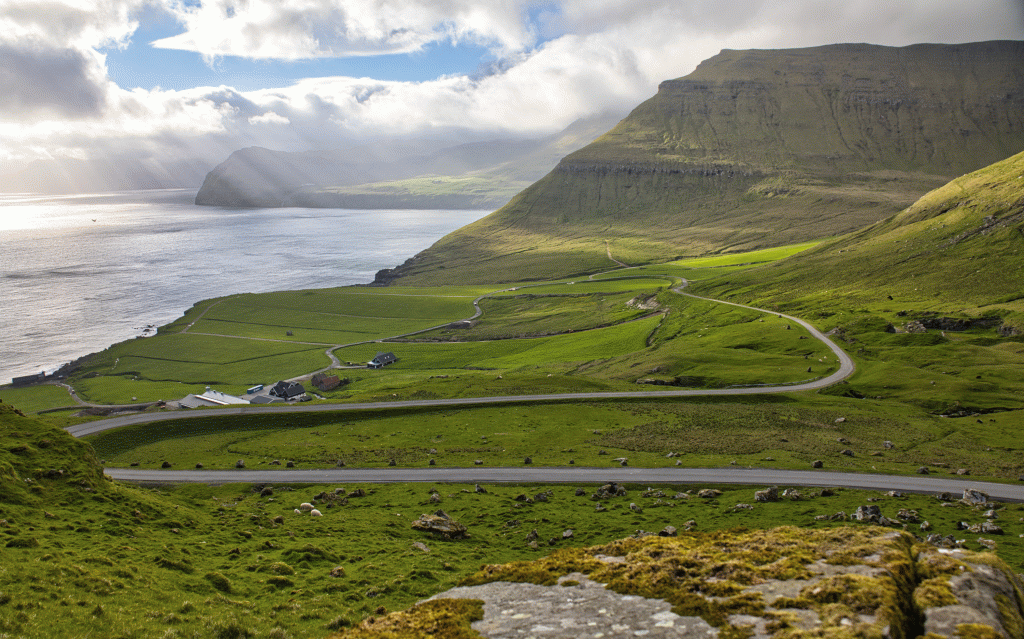 View of the village Syðradalur. In the background to the left is the western part of the village Norðradalur. Picture: Óli Gardshodn
 -
 The mountain slope between the settlements Syðradalur and Norðradalur, called Tungulíð. The relatively large and deep rain gorges in the northern part make the trail cozy. Picture: Óli Gardshodn
 -
 There are several cosy gullies in the northern part of the mountain slope Tungulíð, between the settlements Syðradalur and Norðradalur. This one goes down to the gorge Tungulíðgjógv. To the right is the western part of the village Norðradalur. In the background the island of Vágar. Picture: Óli Gardshodn
 -
 The large gorge Dalagjógv, which divides the two settlements in the village Norðradalur. Picture: Óli Gardshodn
 -
 It is very beautiful to walk up from Norðradalur to the pass Sunnaraskarð in Norðradalur (415 m.). It is especially beautiful above Rossaryggi, where you have a very good view of the entire Norðradalur valley. This is a great place to enjoy a cup of coffee. Picture: Óli Gardshodn
 -
 Slightly south of the pass Sunnaraskarð in Norðradalur, there is a good view east towards the island of Eysturoy. Picture: Óli Gardshodn
 -
 The view a little south of the pass Sunnaraskarð in Syðradalur, south towards the pass Sundshálsur (278 m.) And the mountain Húsareyn (345 m.). Picture: Óli Gardshodn
-
View from the pass Reiðskarð (419 m.) down on the valley Syðradalur. Picture: Óli Gardshodn
-
The northern part of the valley Syðradalur. In the background the island of Koltur. Picture: Óli Gardshodn
-
View of the village Syðradalur. In the background to the left is the western part of the village Norðradalur. Picture: Óli Gardshodn
-
The mountain slope between the settlements Syðradalur and Norðradalur, called Tungulíð. The relatively large and deep rain gorges in the northern part make the trail cozy. Picture: Óli Gardshodn
-
There are several cosy gullies in the northern part of the mountain slope Tungulíð, between the settlements Syðradalur and Norðradalur. This one goes down to the gorge Tungulíðgjógv. To the right is the western part of the village Norðradalur. In the background the island of Vágar. Picture: Óli Gardshodn
-
The large gorge Dalagjógv, which divides the two settlements in the village Norðradalur. Picture: Óli Gardshodn
-
It is very beautiful to walk up from Norðradalur to the pass Sunnaraskarð in Norðradalur (415 m.). It is especially beautiful above Rossaryggi, where you have a very good view of the entire Norðradalur valley. This is a great place to enjoy a cup of coffee. Picture: Óli Gardshodn
-
Slightly south of the pass Sunnaraskarð in Norðradalur, there is a good view east towards the island of Eysturoy. Picture: Óli Gardshodn
-
The view a little south of the pass Sunnaraskarð in Syðradalur, south towards the pass Sundshálsur (278 m.) And the mountain Húsareyn (345 m.). Picture: Óli Gardshodn
Sundshálsur - Syðradalur - Norðradalur - Sundshálsur: An 11 km challenging hiking loop with stunning views, rugged terrain, and deep gorges.
The route starts by the large parking place 800-meters north of Sundshálsur. Follow the road up towards the pond in Sundshálsur and then continue straight to Reiðskarð (also called Norðarskarð in Syðradal).
The path is easy to walk; this path is used by many people from Tórshavn, which means the track is easy to see and has several cairns laid just above the trail. The terrain is very flat, and the view spanning Eysturoy and south towards Tórshavn is visible. It is gorgeous to arrive and see the pond with Koltur in the background.
You will walk down to the new cultivating road that the Syðradal farmer has made down in Niðarabotn. From there, you will walk down to the gate which leads you across Breiðá at about 100-meters from the main road. Across the river, the route leads you to the end of the cultivating road and then along the red poles to Norðadal. There are no cairns on this route, but the poles are close enough to each other, making it easy to follow them. When you arrive at the pass in Tungulið, the first part can be a bit challenging because you are close to the edge of the hill. Here it is beautiful to walk north through the pass in Tungulið. Below you can see onto the containers where much surf can be seen, and further out, you will see Koltur with its unique shape.
You arrive at several large and deep gullies when you come halfway north through Tungulið, opposite Hellisgil. The scenery is beautiful here.
From Tunguliðgjógv, you will walk up about 108-meters, it is easier to walk, and there is a gate you can walk through. From there, it is a straight walk to the stone gate in Norðradal.
You can walk straight towards Sunnarabotn by the stone gate, or first walk along the village path through the beautiful Dalagjógv, which we recommend. In the gorge, you will have to walk down a narrow ledge.
Then you will walk back and head through the stone gate. Follow the poles on the left side up towards Sunnaraskarð. It is pretty steep walking up Sunnarabotn; however, the terrain is grassy and decent. Out of the botn, you will continue up the north side of the river, up through the steep Rossarygg, which is about 70-meters high—up the small valley right above. The first cairn above Rossarygg is an excellent place to rest and enjoy the view across Norðradal and all the way west to Vágafjøll. On the other side of the river, under the narrow ledge of Tungulíðfjall, you can see a different path up through Sunnarabotn and heading up through Hellissvað. This path was usually used for horses, which is why it is called Rossagøta (Horse Path). Lore tells of a priest heading out of Tórshavn to Norðradal to preach Christianity. This was when a portion of Faroese believed in Asgard and northern mythology. The men from the north in Tórshavn came to accompany this man during his journey and disapproved of his trip to Norðradal. They decided that they would throw him over once they made their way through the pass. The priest, who was unaware, was pushed off Rossarygg and did not stop falling until he hit a flat surface; by then, his neck was broken, and he died. The pass today is called Lýðarssonarskarð or Lýsnarskarð (Light Pass)—which is likely because of this priest.
You continue walking the short way up the valley above and then continue up to Sunnara pass. Here you can enjoy the fantastic view spanning Kallbaksfjørð and east of Eysturoy. Finally, from that point on, it is a flat and decent walk along the stony soil to Sundhálsur.


Sundshálsur - Syðradalur - Norðradalur - Sundshálsur
In Sundshálsur, there is decent parking close to the main road. Park in the area indicated by the green lines and then follow the blue lines which lead you to the path.

Syðradalur - Sundshálsur - Norðradalur - Sundshálsur
Facts

Duration

distance

Peak

Elevation
 10+
Due to length, altitude, and specific stretches walking close to the edge under Tungulið.
10+
Due to length, altitude, and specific stretches walking close to the edge under Tungulið.
 Difficult
- It is steep walking up through Rossarygg into Sunnarabotn in Norðradal.
Difficult
- It is steep walking up through Rossarygg into Sunnarabotn in Norðradal.
 Frome Sundshálsur to both Reiðskarð and Sunnaraskarð, the path is gravelly and stony; however, the track is relatively flat and easy to walk on.
From Reiðskarð down to the road in Syðradal, it is changing terrain; at the top, there are several small stones, and at the bottom, it is wet.
From Syðradal to Norðradal and further up Sunnaraskarð, the terrain is grassy all the way, although steep along Rossarygg in Sunnarabotn. There are pretty steep areas in the gorge, and it can be slippery if walking on the bedrock through the pass.
Frome Sundshálsur to both Reiðskarð and Sunnaraskarð, the path is gravelly and stony; however, the track is relatively flat and easy to walk on.
From Reiðskarð down to the road in Syðradal, it is changing terrain; at the top, there are several small stones, and at the bottom, it is wet.
From Syðradal to Norðradal and further up Sunnaraskarð, the terrain is grassy all the way, although steep along Rossarygg in Sunnarabotn. There are pretty steep areas in the gorge, and it can be slippery if walking on the bedrock through the pass.
