


You haven’t got any favourites yet
This is where you can collect inspiration, articles, events and places that interest you.
Click the icon on pages and they’ll appear here.
Your favourites
Inspiration & Articles
Events & Tours
Places
Hiking
INSPIRATION & ARTICLES
EVENTS & HIKES
Places
Tórshavn City-walk


Link Copied!


Experience the scenic Tórshavn City-walk: a peaceful 2-hour hike through gardens, rivers, waterfalls, and stunning city views.
The route starts at Visit Tórshavn in Steinatún. Walk up along Niels Finsensgøta and turn left towards the road called Við Havnará, where the statue Ormabani (tr. “Snake Slayer”) by the artist Tróndur Paturson stands in the river. Then continue up towards the grove; this is a peaceful and cosy place to enter. It is located by a river filled with trees, ducks, birds and other people seeking peace or simply walking through on their way home from work.
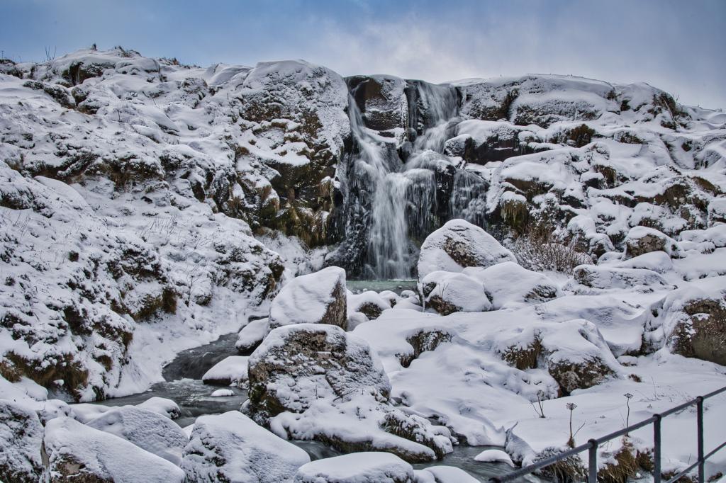
Once you have made it through the grove, continue past the football stadium, swimming hall, and Tórsbreyt. Then continue along the road Undir Svartafossi where you reach Svartifossur after walking a total of 2 kilometres. Many people, including couples, stroll along this gorgeous romantic waterfall, where the two rivers beautifully join together to form a single channel.
Continue along the narrow path leading above the waterfall and then along Ternuryggur. This area was founded in 1938 as a garden space with around 130 smaller plots available for people to rent. In those days, it was far outside of Tórshavn. Once the war broke out in 1939 and foreign seamen were stranded here, the council wanted to initiate a support campaign so these men could do some work and earn money. Amongst other things, these men worked on the paths in this garden space. Continue past the cosy garden space and walk towards Villingafossur. Above lies the Tórshavn water supply, where you can see the water embankment from 1988, which stands at an altitude of 270 meters.
Continue up the steep path in Ketturðin; once up there, you are at the route's halfway point. It is gorgeous walking up here with the lovely scene spanning across Hoyvík, Tórshavn, Argir, Nólsoy and even further north towards Skálafjørður and Eysturoy with the northern mountains.
In this area, there are a great number of large stones spread across the road south by Brúnni—south to Keldurnar and then by the telecommunication masts, which are located above Hotel Føroyar. These can possibly be traced back to the ice age, during which they could have been washed out from a sluice under the ice.
Whilst enjoying the excellent view, walk south towards Keldurnar, where the road crosses the old village path leading to Syðradalur and Norðadalur. Turn down the village path after Keldurnar towards á Varða, where you will arrive at a stone fence gate. Right before you arrive at the gate, it is possible to walk 150 meters north along the fence above the fire station leading to Varðholan, which is a cavern with a large stone in the middle. Varðholan was used for both mass meetings and as a hiding spot when hiding from pirates. Scouts also would go on weekend trips here– which was considered far outside of Tórshavn at the time. Then continue through the gate, across Oyggjarvegur and down the path towards the road Írarók. At the bottom of Varðagøta, you walk past the childhood home of the artist and Tórshavn’s Citizen of Honour, William Heinesen. Then continue walking down to the grove, where you arrive at a memorial cairn set in memory of the seamen that died during the Second World War. By both lakes below the memorial is rich birdlife— also some interesting birds. Continue walking downward.
Once you exit the grove and reach the bridge, turn right along the path heading towards the Sankta Frans school. There you will walk past the gorgeous bronze statue of the dream girl Tarira, also known as Álvagentan (tr. “The Elf Girl”), created by Hans Pauli Olsen and set in memory of William Heinesen. Here is where the yearly high school graduation meetings are held.
Then continue down along Tórsgøta to Steinatún, where the route ends.


Steinatún
City busses frequently stop at Steinatún.
See the photo for parking information in downtown Tórshavn.

Steinatún
Facts

Duration

distance

Peak

Elevation
 8+. The walk is too long for smaller children, unless they're carried for a part of the trip
 Medium
-
Medium
-
 Excellent foot paths all the way except for a short jump accross a small river. The river can get quite large in rainy or snowy weather conditions.
